Dennebrœucq
Dennebrœucq (French pronunciation: [dɛnbʁœk]; West Flemish: Denebroek) is a commune in the Pas-de-Calais department in the Hauts-de-France region of France. The medieval Flemish placename used to be Denebroek[2]
Dennebrœucq
Denebroek | |
|---|---|
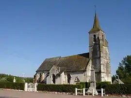 The church of Dennebrœucq | |
 Coat of arms | |
Location of Dennebrœucq 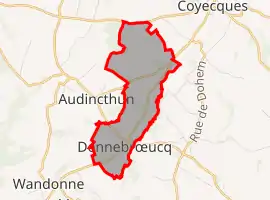 | |
 Dennebrœucq  Dennebrœucq | |
| Coordinates: 50°34′27″N 2°09′14″E | |
| Country | France |
| Region | Hauts-de-France |
| Department | Pas-de-Calais |
| Arrondissement | Saint-Omer |
| Canton | Fruges |
| Intercommunality | Pays de Saint-Omer |
| Government | |
| • Mayor (2020–2026) | Christian Crunelle |
| Area 1 | 3.73 km2 (1.44 sq mi) |
| Population | 395 |
| • Density | 110/km2 (270/sq mi) |
| Time zone | UTC+01:00 (CET) |
| • Summer (DST) | UTC+02:00 (CEST) |
| INSEE/Postal code | 62267 /62560 |
| Elevation | 53–140 m (174–459 ft) (avg. 70 m or 230 ft) |
| 1 French Land Register data, which excludes lakes, ponds, glaciers > 1 km2 (0.386 sq mi or 247 acres) and river estuaries. | |
Geography
The village spreads along the D159 road, 12 miles (19 km) south of Saint-Omer.
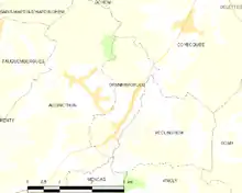
Map of the commune and adjacent places
History
Dennebrœucq is home to the adventure playground Dennlys Parc, created in 1983 on the site of the old watermill.
Population
| Year | Pop. | ±% p.a. |
|---|---|---|
| 1968 | 279 | — |
| 1975 | 257 | −1.17% |
| 1982 | 269 | +0.65% |
| 1990 | 310 | +1.79% |
| 1999 | 314 | +0.14% |
| 2007 | 356 | +1.58% |
| 2012 | 369 | +0.72% |
| 2017 | 389 | +1.06% |
| Source: INSEE[3] | ||
Places of interest
- The church of St.Leger, dating from the sixteenth century.
- The nineteenth century chapel.
References
- "Populations légales 2019". The National Institute of Statistics and Economic Studies. 29 December 2021.
- Dennebrœucq/Denebroek: proussel.voila.net Archived 2015-07-05 at the Wayback Machine
- Population en historique depuis 1968, INSEE
This article is issued from Wikipedia. The text is licensed under Creative Commons - Attribution - Sharealike. Additional terms may apply for the media files.