Croydon, New Hampshire
Croydon is a town in Sullivan County, New Hampshire, United States. The population was 801 at the 2020 census.[2]
Croydon, New Hampshire | |
|---|---|
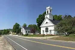 Croydon town center: Town Hall on left, First Congregational Church on right | |
 Location in Sullivan County and the state of New Hampshire. | |
| Coordinates: 43°27′02″N 72°09′47″W | |
| Country | United States |
| State | New Hampshire |
| County | Sullivan |
| Incorporated | 1763 |
| Villages | Croydon Croydon Flat |
| Government | |
| • Board of Selectmen | James Harding Carol Marsh George Caccavaro |
| Area | |
| • Total | 37.5 sq mi (97.2 km2) |
| • Land | 36.8 sq mi (95.2 km2) |
| • Water | 0.8 sq mi (2.0 km2) 2.07% |
| Elevation | 892 ft (272 m) |
| Population (2020) | |
| • Total | 801 |
| • Density | 22/sq mi (8.4/km2) |
| Time zone | UTC-5 (Eastern) |
| • Summer (DST) | UTC-4 (Eastern) |
| ZIP code | 03773 |
| Area code(s) | 603 |
| FIPS code | 33-16340 |
| GNIS feature ID | 0873572 |
| Website | croydon-nh |
History
Incorporated in 1763, the town takes its name from Croydon, a suburb of London, England.[3]
Croydon was home to Ruel Durkee, a powerful 19th century political boss in the state. The town of "Coniston" in the 1906 best-selling novel of the same name, by American author Winston Churchill, is based on Croydon, and Durkee was portrayed as "Jethro Bass". The local Coniston General Store is named after the novel,[4][5] as are YMCA Camp Coniston and Lake Coniston in the eastern part of the town.[6]
Geography
According to the United States Census Bureau, the town has a total area of 37.5 square miles (97.2 km2), of which 36.8 square miles (95.2 km2) are land and 0.77 square miles (2.0 km2) are water, comprising 2.07% of the town.[1] The highest point in town is Croydon Peak, at 2,760 feet (840 m) above sea level near the northwest corner of the town. The North Branch Sugar River flows southward through the east-central part of the town. Croydon lies fully within the Connecticut River watershed.[7]
Croydon is home to Corbin Park, one of the largest private game reserves in New England. The 24,000-acre (9,700 ha) fenced-in expanse of woodlands and mountainous terrain features bison, European boar and elk and extends into neighboring towns.[8]
Adjacent municipalities
- Grantham, New Hampshire (north)
- Springfield, New Hampshire (northeast)
- Sunapee, New Hampshire (east)
- Newport, New Hampshire (south)
- Cornish, New Hampshire (west)
- Plainfield, New Hampshire (northwest)
Demographics
| Historical population | |||
|---|---|---|---|
| Census | Pop. | %± | |
| 1790 | 537 | — | |
| 1800 | 984 | 83.2% | |
| 1810 | 864 | −12.2% | |
| 1820 | 1,060 | 22.7% | |
| 1830 | 1,057 | −0.3% | |
| 1840 | 956 | −9.6% | |
| 1850 | 861 | −9.9% | |
| 1860 | 755 | −12.3% | |
| 1870 | 652 | −13.6% | |
| 1880 | 608 | −6.7% | |
| 1890 | 512 | −15.8% | |
| 1900 | 372 | −27.3% | |
| 1910 | 324 | −12.9% | |
| 1920 | 230 | −29.0% | |
| 1930 | 269 | 17.0% | |
| 1940 | 312 | 16.0% | |
| 1950 | 349 | 11.9% | |
| 1960 | 312 | −10.6% | |
| 1970 | 396 | 26.9% | |
| 1980 | 457 | 15.4% | |
| 1990 | 627 | 37.2% | |
| 2000 | 661 | 5.4% | |
| 2010 | 764 | 15.6% | |
| 2020 | 801 | 4.8% | |
| U.S. Decennial Census[9] | |||
As of the census[10] of 2000, there were 661 people, 264 households, and 194 families living in the town. The population density was 17.8 people per square mile (6.9/km2). There were 354 housing units at an average density of 9.5 per square mile (3.7/km2). The racial makeup of the town was 97.43% White, 0.45% Native American, 0.15% Asian, 0.76% from other races, and 1.21% from two or more races. Hispanic or Latino of any race were 0.61% of the population.
There were 264 households, out of which 29.2% had children under the age of 18 living with them, 58.0% were married couples living together, 8.3% had a female householder with no husband present, and 26.5% were non-families. 19.3% of all households were made up of individuals, and 8.7% had someone living alone who was 65 years of age or older. The average household size was 2.50 and the average family size was 2.71.
In the town, the population was spread out, with 22.7% under the age of 18, 4.7% from 18 to 24, 30.4% from 25 to 44, 30.0% from 45 to 64, and 12.3% who were 65 years of age or older. The median age was 41 years. For every 100 females, there were 109.2 males. For every 100 females age 18 and over, there were 102.0 males.
The median income for a household in the town was $49,688, and the median income for a family was $50,556. Males had a median income of $31,992 versus $26,544 for females. The per capita income for the town was $21,403. About 2.5% of families and 4.9% of the population were below the poverty line, including 5.0% of those under age 18 and 9.7% of those age 65 or over.
Politics
In recent decades, Croydon has supported Republicans in presidential elections.
| Year | Democratic | Republican | Third Parties |
|---|---|---|---|
| 2016[11] | 30.00% 126 | 64.52% 271 | 5.48% 23 |
| 2012[12] | 44.44% 196 | 52.83% 233 | 2.72% 12 |
| 2008[13] | 45.27% 182 | 53.73% 216 | 1.00% 4 |
| 2004[14] | 38.57% 157 | 60.93% 248 | 0.49% 2 |
| 2000[15] | 27.86% 90 | 63.47% 205 | 8.67% 28 |
| 1996[16] | 33.33% 95 | 53.68% 153 | 12.98% 37 |
| 1988[17] | 31.67% 70 | 67.42% 149 | 0.91% 2 |
| 1984[18] | 29.63% 56 | 70.37% 133 | 0.00% 0 |
Notable people
- Augusta Cooper Bristol (1835–1910), poet, lecturer
References
- "2021 U.S. Gazetteer Files – New Hampshire". United States Census Bureau. Retrieved January 6, 2022.
- "Census - Geography Profile: Croydon town, Sullivan County, New Hampshire". Retrieved December 24, 2021.
- New Hampshire Town Names and Whence They Came ISBN 978-0-872-33009-2 p. 9
- Henderson, Brooks. Winston Churchill's Country, The Bookman (New York), August 1915, pp. 607, 617
- New Hampshire: A Guide to the Granite State, p. 349 (1938)
- "History - YMCA Camp Coniston".
- Foster, Debra H.; Batorfalvy, Tatianna N.; Medalie, Laura (1995). Water Use in New Hampshire: An Activities Guide for Teachers. U.S. Department of the Interior and U.S. Geological Survey.
- "Corbin Park Hunting Preserve in New Hampshire". Free New Hampshire Blog. June 4, 2008. Retrieved June 20, 2011.
- "Census of Population and Housing". Census.gov. Retrieved June 4, 2016.
- "U.S. Census website". United States Census Bureau. Retrieved 2008-01-31.
- "NH Elections Database » 2016 President General Election".
- "NH Elections Database » 2012 President General Election".
- "NH Elections Database » 2008 President General Election".
- "NH Elections Database » 2004 President General Election".
- "NH Elections Database » 2000 President General Election".
- "NH Elections Database » 1996 President General Election".
- "NH Elections Database » 1988 President General Election".
- "NH Elections Database » 1984 President General Election".
External links
Places adjacent to Croydon, New Hampshire | |
|---|---|
Municipalities and communities of Sullivan County, New Hampshire, United States | ||
|---|---|---|
| City | 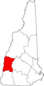 Map of New Hampshire highlighting Sullivan County | |
| Towns | ||
| CDPs | ||
| Other villages | ||
| ||