Courcelles-sous-Moyencourt
Courcelles-sous-Moyencourt (Picard: Courchelle-dsous-Moyincourt) is a commune in the northern French department of Somme.
Courcelles-sous-Moyencourt | |
|---|---|
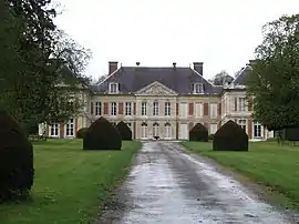 The château of Courcelles-sous-Moyencourt | |
Location of Courcelles-sous-Moyencourt 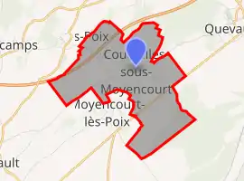 | |
 Courcelles-sous-Moyencourt  Courcelles-sous-Moyencourt | |
| Coordinates: 49°48′51″N 2°02′43″E | |
| Country | France |
| Region | Hauts-de-France |
| Department | Somme |
| Arrondissement | Amiens |
| Canton | Poix-de-Picardie |
| Intercommunality | CC Somme Sud-Ouest |
| Government | |
| • Mayor (2020–2026) | Jean-Pierre Chopin[1] |
| Area 1 | 6.78 km2 (2.62 sq mi) |
| Population | 144 |
| • Density | 21/km2 (55/sq mi) |
| Time zone | UTC+01:00 (CET) |
| • Summer (DST) | UTC+02:00 (CEST) |
| INSEE/Postal code | 80218 /80290 |
| Elevation | 97–162 m (318–531 ft) (avg. 130 m or 430 ft) |
| 1 French Land Register data, which excludes lakes, ponds, glaciers > 1 km2 (0.386 sq mi or 247 acres) and river estuaries. | |
Geography
The commune is situated on the D258 road, between the A29 autoroute and the N29 road some 15 miles (24 km) southwest of Amiens.
Population
| Year | 1962 | 1968 | 1975 | 1982 | 1990 | 1999 | 2006 |
|---|---|---|---|---|---|---|---|
| Population | 115 | 118 | 103 | 119 | 133 | 141 | 140 |
| From the year 1962 on: No double counting—residents of multiple communes (e.g. students and military personnel) are counted only once. | |||||||
See also
References
- "Répertoire national des élus: les maires". data.gouv.fr, Plateforme ouverte des données publiques françaises (in French). 2 December 2020.
- "Populations légales 2019". The National Institute of Statistics and Economic Studies. 29 December 2021.
| Wikimedia Commons has media related to Courcelles-sous-Moyencourt. |
This article is issued from Wikipedia. The text is licensed under Creative Commons - Attribution - Sharealike. Additional terms may apply for the media files.