List of counties in Ohio
There are 88 counties in the U.S. state of Ohio. Nine of them existed at the time of the Ohio Constitutional Convention in 1802.[1] A tenth county, Wayne, was established on August 15, 1796, and encompassed roughly the present state of Michigan.[2] During the Convention, the county was opposed to statehood, and was not only left out of the Convention, but dissolved; the current Wayne County is in northeastern Ohio, considerably distant from the area that was the original Wayne County.[1]
The Ohio Constitution allows counties to set up a charter government as many cities and villages do,[3] but only Summit and Cuyahoga counties have done so,[4] the latter having been approved by voters in November 2009.[5] Counties do not possess home rule powers and can do only what has been expressly authorized by the Ohio General Assembly. The elected county officials in Ohio county governments include three commissioners, a sheriff (the highest law enforcement officer in the county); prosecutor (equivalent of a district attorney in other states); coroner, engineer, auditor, treasurer, and clerk of courts.[6][7]
Population figures are based on the 2021 vintage Census population estimates. The population of Ohio was 11,780,017 at that time, a decrease of 0.2% from 2020. The average population of Ohio's counties was 133,864; Franklin County was the most populous (1,321,414) and Vinton County was the least (12,696). The average land area is 464 sq mi (1,200 km2). The largest county by area is Ashtabula County at 702.44 sq mi (1,819.3 km2), and its neighbor, Lake County, is the smallest at 228.21 sq mi (591.1 km2). The total area of the state is 40,860.69 sq mi (105,828.7 km2).[8][9]
The Federal Information Processing Standard (FIPS) is used by the U.S. government to uniquely identify counties, and is provided for each entry. These codes link to the United States Census Bureau's "quick facts" for each county. Ohio's FIPS code of 39 is used to distinguish from counties in other states. For example, Adams County's unique nationwide identifier is 39001.[10] However, the Bureau of Motor Vehicles and Department of Transportation instead identify counties by consecutive numbers and three-letter abbreviations,[11] respectively. For historic preservation purposes, Ohio History Connection refers to counties by two- and three-letter abbreviations in the Ohio Archaeological Inventory and Ohio Historic Inventory, respectively.[12]
List of counties
| County |
FIPS code[10] | County Seat[13] | Est.[14] | Origin[15] | Etymology[14][15] | Population[10][13] [16] | Area[13] | Map |
|---|---|---|---|---|---|---|---|---|
| Adams County | 001 | West Union | Jul 10, 1797 | Hamilton County | John Adams (1735–1826), President of the United States when the county was organized | 27,542 | 583.91 sq mi (1,512 km2) | 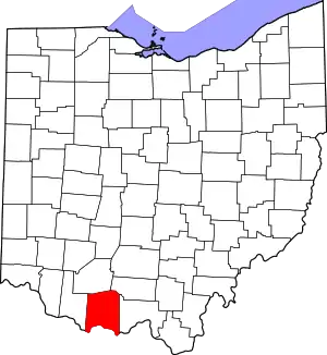 |
| Allen County | 003 | Lima | Mar 1, 1820 | Shelby County | John Allen (1771/2-1813), a War of 1812 colonel[17] | 101,670 | 404.43 sq mi (1,047 km2) | 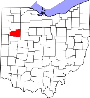 |
| Ashland County | 005 | Ashland | Feb 24, 1846 | Wayne, Richland, Huron, and Lorain Counties | Ashland, home of U.S. Senator from Kentucky Henry Clay | 52,316 | 424.37 sq mi (1,099 km2) | 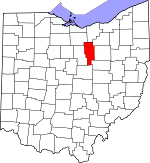 |
| Ashtabula County | 007 | Jefferson | Jun 7, 1807 | Trumbull and Geauga Counties | Ashtabula River, which means "fish river" in an Algonquian language[18] | 97,337 | 702.44 sq mi (1,819 km2) | 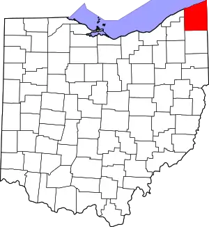 |
| Athens County | 009 | Athens | Mar 1, 1805 | Washington County | Athens in Greece | 62,056 | 506.76 sq mi (1,313 km2) | 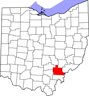 |
| Auglaize County | 011 | Wapakoneta | Feb 14, 1848 | Allen, Mercer, Darke, Hardin, Logan, Shelby, and Van Wert Counties | Auglaize River, which means "fallen timbers river" in the Shawnee Indian language | 46,141 | 401.25 sq mi (1,039 km2) | 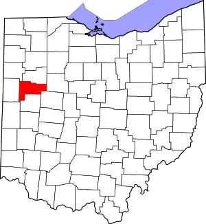 |
| Belmont County | 013 | St. Clairsville | Sep 7, 1801 | Jefferson and Washington Counties | Belle monte, which means "beautiful mountain" in French | 65,849 | 537.35 sq mi (1,392 km2) | 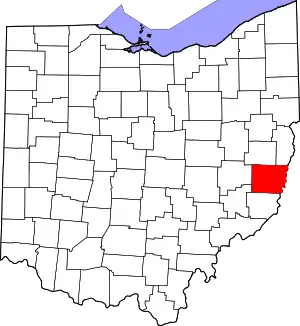 |
| Brown County | 015 | Georgetown | Mar 1, 1818 | Adams and Clermont Counties | General Jacob Brown (1775–1828), an officer of the War of 1812 | 43,662 | 491.76 sq mi (1,274 km2) | 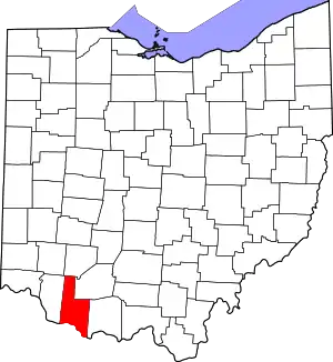 |
| Butler County | 017 | Hamilton | May 1, 1803 | Hamilton County | General Richard Butler (1743–1791), killed at the Battle of the Wabash | 390,234 | 467.27 sq mi (1,210 km2) | 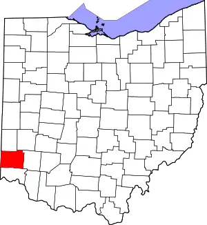 |
| Carroll County | 019 | Carrollton | Jan 1, 1833 | Columbiana, Stark, Harrison, Jefferson, and Tuscarawas Counties | Charles Carroll (1737–1832), last surviving signer of the United States Declaration of Independence | 26,691 | 394.67 sq mi (1,022 km2) | 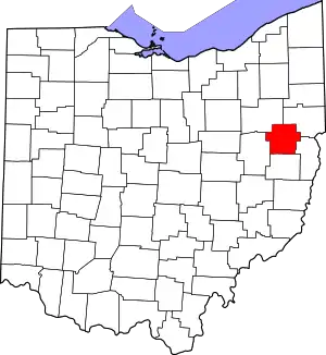 |
| Champaign County | 021 | Urbana | Mar 1, 1805 | Greene and Franklin Counties | French for "a plain", describing the land in the area | 38,699 | 428.56 sq mi (1,110 km2) | 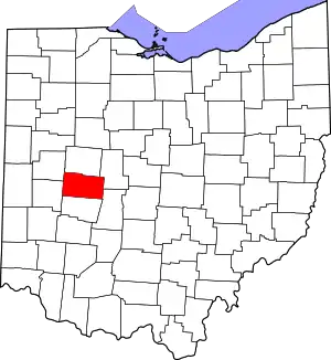 |
| Clark County | 023 | Springfield | Mar 1, 1818 | Champaign, Madison, and Greene Counties | General George Rogers Clark (1752–1818), defeated the Shawnee Indians in a battle near the Springfield area | 135,633 | 399.86 sq mi (1,036 km2) | 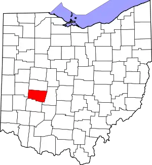 |
| Clermont County | 025 | Batavia | Dec 6, 1800 | Hamilton County | French for "clear mountain" | 209,642 | 451.99 sq mi (1,171 km2) | 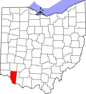 |
| Clinton County | 027 | Wilmington | Mar 1, 1810 | Highland and Warren Counties | George Clinton (1739–1812), vice-president when the county was organized | 42,004 | 410.88 sq mi (1,064 km2) | 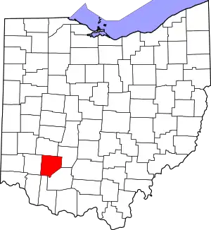 |
| Columbiana County | 029 | Lisbon | May 1, 1803 | Jefferson and Washington Counties | Christopher Columbus, European explorer of the Americas | 101,310 | 532.46 sq mi (1,379 km2) | 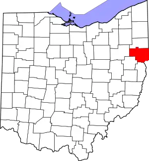 |
| Coshocton County | 031 | Coshocton | Jan 31, 1810 | Muskingum and Tuscarawas Counties | Delaware Indian word meaning "union of waters" | 36,618 | 564.07 sq mi (1,461 km2) | 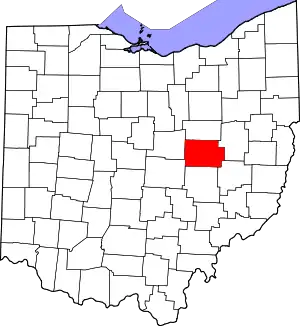 |
| Crawford County | 033 | Bucyrus | Apr 1, 1820 | Delaware County | Colonel William Crawford (1732–1782), Revolutionary War officer | 41,754 | 402.11 sq mi (1,041 km2) | 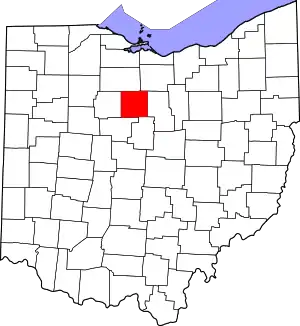 |
| Cuyahoga County | 035 | Cleveland | Jun 7, 1807 | Geauga County | Cuyahoga River, which means "crooked river" in an Iroquoian language[19] | 1,249,387 | 458.49 sq mi (1,187 km2) | 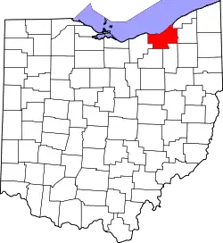 |
| Darke County | 037 | Greenville | Jan 3, 1809 | Miami County | General William Darke (1736–1801), Revolutionary War officer | 51,597 | 599.80 sq mi (1,553 km2) | 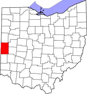 |
| Defiance County | 039 | Defiance | Apr 7, 1845 | Williams, Henry, and Paulding Counties | Fort Defiance, built in 1794 by General Anthony Wayne | 38,144 | 411.16 sq mi (1,065 km2) | 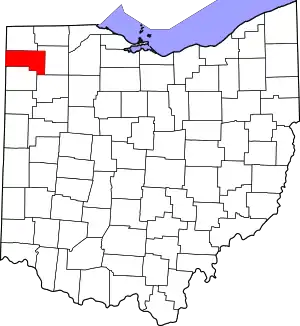 |
| Delaware County | 041 | Delaware | Apr 1, 1808 | Franklin County | Delaware Indians | 220,740 | 442.41 sq mi (1,146 km2) | 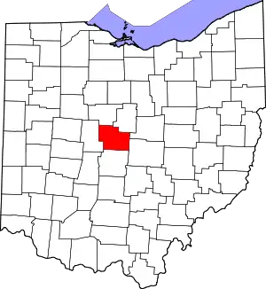 |
| Erie County | 043 | Sandusky | Mar 15, 1838 | Huron and Sandusky Counties | Erie Indians | 74,852 | 254.88 sq mi (660 km2) | 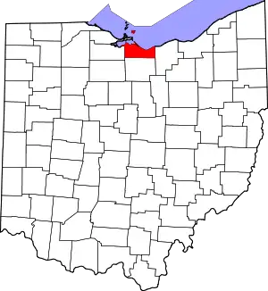 |
| Fairfield County | 045 | Lancaster | Dec 9, 1800 | Ross and Washington Counties | Named for the beauty of its "fair fields" | 161,064 | 505.11 sq mi (1,308 km2) | 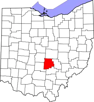 |
| Fayette County | 047 | Washington Court House | Mar 1, 1810 | Ross and Highland Counties | Gilbert du Motier, marquis de La Fayette, French military officer and aristocrat who participated in both the American and French revolutions | 28,906 | 406.58 sq mi (1,053 km2) | 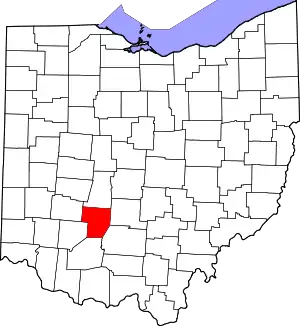 |
| Franklin County | 049 | Columbus | Apr 30, 1803 | Ross and Wayne Counties | Benjamin Franklin (1706–1791), Founding Father, author, printer, political theorist, scientist, inventor, and statesman | 1,321,414 | 539.87 sq mi (1,398 km2) | 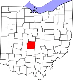 |
| Fulton County | 051 | Wauseon | Apr 1, 1850 | Lucas, Henry, and Williams Counties | Robert Fulton (1765–1815), inventor of the steamboat[20] | 42,450 | 406.78 sq mi (1,054 km2) | 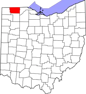 |
| Gallia County | 053 | Gallipolis | Apr 30, 1803 | Washington and Adams Counties | Gaul, the ancient name of France | 29,158 | 468.78 sq mi (1,214 km2) | 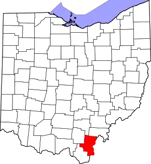 |
| Geauga County | 055 | Chardon | Mar 1, 1806 | Trumbull County | An Indian word meaning "raccoon" | 95,565 | 403.66 sq mi (1,045 km2) | 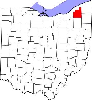 |
| Greene County | 057 | Xenia | May 1, 1803 | Hamilton and Ross Counties | General Nathanael Greene (1742–1786), Revolutionary War officer | 168,412 | 414.88 sq mi (1,075 km2) | 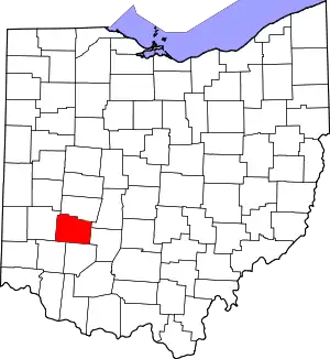 |
| Guernsey County | 059 | Cambridge | Mar 1, 1810 | Belmont and Muskingum Counties | Island of Guernsey, from where most of the settlers originated | 38,287 | 521.90 sq mi (1,352 km2) | 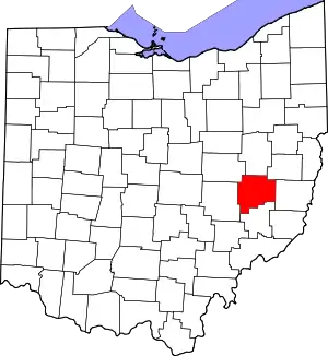 |
| Hamilton County | 061 | Cincinnati | Jan 2, 1790 | One of the original counties | Alexander Hamilton (1755/7-1804), Secretary of the Treasury when the county was organized | 826,139 | 407.36 sq mi (1,055 km2) | 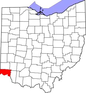 |
| Hancock County | 063 | Findlay | Apr 1, 1820 | Logan County | John Hancock (1737–1793), president of the Continental Congress | 74,656 | 531.35 sq mi (1,376 km2) | 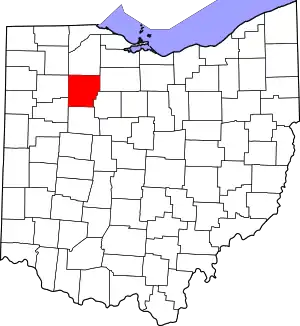 |
| Hardin County | 065 | Kenton | Apr 1, 1820 | Logan County | General John Hardin (1753–1792), Revolutionary War officer | 30,621 | 470.29 sq mi (1,218 km2) | 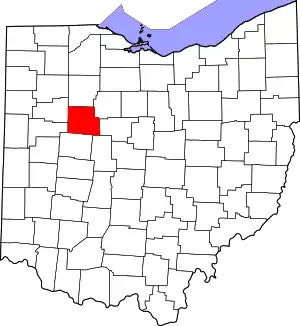 |
| Harrison County | 067 | Cadiz | Feb 1, 1813 | Jefferson and Tuscarawas Counties | General William Henry Harrison (1773–1841), an officer of the War of 1812 and future President of the United States | 14,477 | 403.53 sq mi (1,045 km2) | 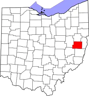 |
| Henry County | 069 | Napoleon | Apr 1, 1820 | Shelby County | Patrick Henry (1736–1799), Revolutionary War-era legislator, orator, and scholar | 27,538 | 416.50 sq mi (1,079 km2) | 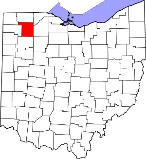 |
| Highland County | 071 | Hillsboro | May 1, 1805 | Ross, Adams, and Clermont Counties | Descriptive of the county's terrain | 43,354 | 553.28 sq mi (1,433 km2) | 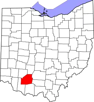 |
| Hocking County | 073 | Logan | Mar 1, 1818 | Athens, Ross, and Fairfield Counties | Possibly derived from the Delaware Indian word "Hoch-Hoch-ing", meaning "bottle" | 28,097 | 422.75 sq mi (1,095 km2) | 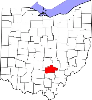 |
| Holmes County | 075 | Millersburg | Jan 20, 1824 | Coshocton, Wayne, and Tuscarawas Counties | Major Andrew Holmes (died 1814), a War of 1812 officer | 44,271 | 422.99 sq mi (1,096 km2) | 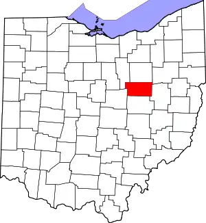 |
| Huron County | 077 | Norwalk | Mar 7, 1809 | Portage and Cuyahoga Counties | Huron Indians | 58,367 | 492.69 sq mi (1,276 km2) | 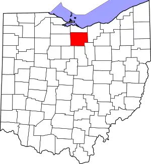 |
| Jackson County | 079 | Jackson | Mar 1, 1816 | Scioto, Gallia, Athens, and Ross Counties | General Andrew Jackson (1767–1845), future President of the United States | 32,511 | 420.28 sq mi (1,089 km2) | 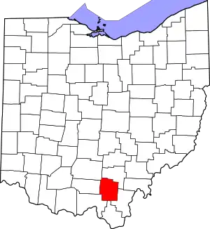 |
| Jefferson County | 081 | Steubenville | Jul 29, 1797 | Washington County | Thomas Jefferson (1743–1826), Vice President when the county was organized, future President of the United States, and principal author of the Declaration of Independence | 64,789 | 409.61 sq mi (1,061 km2) | 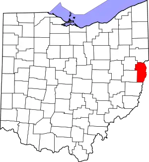 |
| Knox County | 083 | Mount Vernon | Mar 1, 1808 | Fairfield County | General Henry Knox, the first Secretary of War | 62,897 | 527.12 sq mi (1,365 km2) | 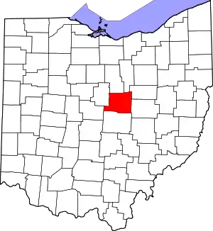 |
| Lake County | 085 | Painesville | Mar 6, 1840 | Geauga and Cuyahoga Counties | Its location on Lake Erie | 232,023 | 228.21 sq mi (591 km2) | 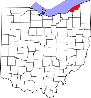 |
| Lawrence County | 087 | Ironton | Dec 21, 1815 | Gallia and Scioto Counties | Captain James Lawrence (1781–1813), naval hero in the War of 1812 | 57,445 | 454.96 sq mi (1,178 km2) | 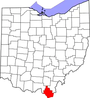 |
| Licking County | 089 | Newark | Mar 1, 1808 | Fairfield County | Licking River, named for the salt licks in the area, or an English pronunciation of the Lenape word W'li/'ik'/nk meaning "where the flood waters recede"[21] | 180,401 | 686.50 sq mi (1,778 km2) | 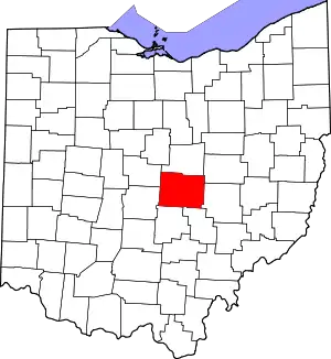 |
| Logan County | 091 | Bellefontaine | Mar 1, 1818 | Champaign County | General Benjamin Logan (c. 1742 – 1802), who destroyed Shawnee Indian towns in the county | 46,035 | 458.44 sq mi (1,187 km2) | 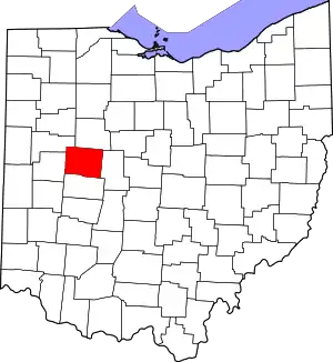 |
| Lorain County | 093 | Elyria | Dec 26, 1822 | Huron, Cuyahoga, and Medina Counties | Province of Lorraine, France | 315,595 | 492.50 sq mi (1,276 km2) | 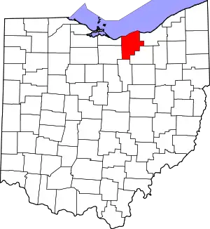 |
| Lucas County | 095 | Toledo | Jun 20, 1835 | Wood, Sandusky, and Huron Counties | Robert Lucas (1781–1853), Governor of Ohio when the county was created | 429,191 | 340.46 sq mi (882 km2) | 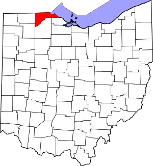 |
| Madison County | 097 | London | Mar 1, 1810 | Franklin County | James Madison (1751–1836), fourth President of the United States | 44,386 | 465.44 sq mi (1,205 km2) | 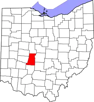 |
| Mahoning County | 099 | Youngstown | Mar 1, 1846 | Columbiana and Trumbull Counties | Mahoning River, from a Lenape word meaning "at the licks" | 226,762 | 415.25 sq mi (1,075 km2) | 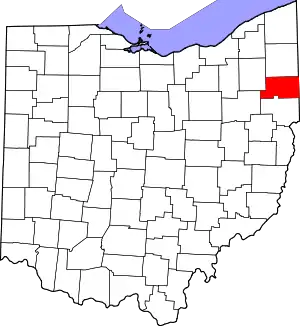 |
| Marion County | 101 | Marion | Apr 1, 1820 | Delaware County | General Francis Marion (1732–1795), lieutenant colonel in the Continental Army and later brigadier general in the American Revolutionary War | 65,291 | 403.84 sq mi (1,046 km2) | 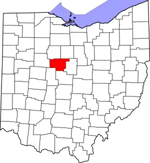 |
| Medina County | 103 | Medina | Feb 18, 1812 | Portage County | Medina, world-renowned religious site in western Saudi Arabia | 183,092 | 423 sq mi (1,096 km2) | 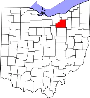 |
| Meigs County | 105 | Pomeroy | Apr 1, 1819 | Gallia and Athens Counties | Return Jonathan Meigs, Jr. (1764–1825), Governor of Ohio and Postmaster General at the time the county was organized | 22,049 | 429.42 sq mi (1,112 km2) | 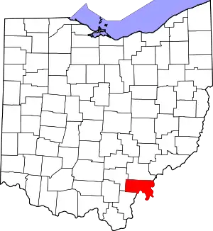 |
| Mercer County | 107 | Celina | Apr 1, 1820 | Darke County | General Hugh Mercer (1726–1777), a Revolutionary War officer | 42,309 | 463.27 sq mi (1,200 km2) | 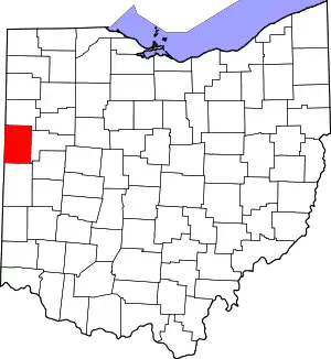 |
| Miami County | 109 | Troy | Mar 1, 1807 | Montgomery County | Miami Indians | 109,264 | 407.04 sq mi (1,054 km2) | 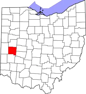 |
| Monroe County | 111 | Woodsfield | Jan 29, 1813 | Belmont, Washington, and Guernsey Counties | James Monroe (1758–1831), Secretary of State when the county was organized and future President of the United States | 13,329 | 455.54 sq mi (1,180 km2) | 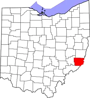 |
| Montgomery County | 113 | Dayton | May 1, 1803 | Hamilton and Wayne Counties | General Richard Montgomery (1738–1775), a Revolutionary War officer | 535,840 | 461.68 sq mi (1,196 km2) | 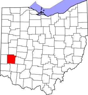 |
| Morgan County | 115 | McConnelsville | Dec 29, 1817 | Washington, Guernsey, and Muskingum Counties | General Daniel Morgan (c. 1735 – 1802), a Revolutionary War officer | 13,682 | 417.66 sq mi (1,082 km2) | 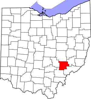 |
| Morrow County | 117 | Mount Gilead | Mar 1, 1848 | Knox, Marion, Delaware, and Richland Counties | Jeremiah Morrow (1771–1852), Governor of Ohio | 35,151 | 406.22 sq mi (1,052 km2) | 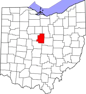 |
| Muskingum County | 119 | Zanesville | Mar 1, 1804[22][23] | Washington and Fairfield Counties | An Indian word meaning "A town by the river" or "by the river side" | 86,408 | 664.63 sq mi (1,721 km2) | 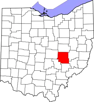 |
| Noble County | 121 | Caldwell | Apr 1, 1851 | Monroe, Washington, Morgan, and Guernsey Counties | Warren P. Noble, an early settler in the area[24] | 14,176 | 399.00 sq mi (1,033 km2) | 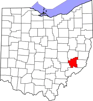 |
| Ottawa County | 123 | Port Clinton | Mar 6, 1840 | Erie, Sandusky, and Lucas Counties | Named for the Ottawa Indians; Ottawa means "trader" in their language | 40,104 | 254.95 sq mi (660 km2) | 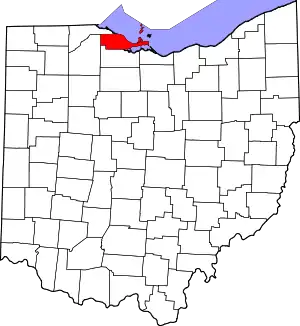 |
| Paulding County | 125 | Paulding | Apr 1, 1820 | Darke County | John Paulding (1758–1818), captor of spy John André during the Revolutionary War | 18,871 | 416.26 sq mi (1,078 km2) | 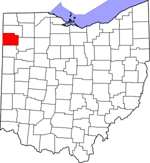 |
| Perry County | 127 | New Lexington | Mar 1, 1818 | Washington, Fairfield, and Muskingum Counties | Commodore Oliver Hazard Perry (1785–1819), a naval officer of the War of 1812 | 35,460 | 409.78 sq mi (1,061 km2) | 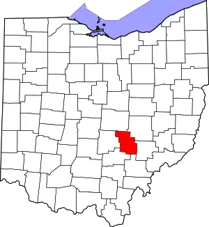 |
| Pickaway County | 129 | Circleville | Mar 1, 1810 | Ross, Fairfield, and Franklin Counties | A misspelling of the Piqua tribe, a branch of the Shawnee | 59,333 | 501.91 sq mi (1,300 km2) | 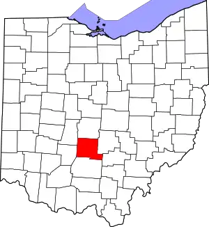 |
| Pike County | 131 | Waverly | Feb 1, 1815 | Ross, Scioto, and Adams Counties | General Zebulon M. Pike (1779–1813), a War of 1812 officer and discoverer of Pikes Peak in Colorado in 1806 | 27,089 | 441.49 sq mi (1,143 km2) | 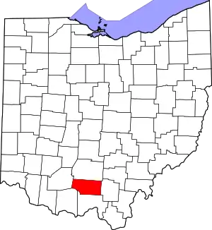 |
| Portage County | 133 | Ravenna | Jun 7, 1807 | Trumbull County | Derived from an Indian portage | 162,382 | 492.39 sq mi (1,275 km2) | 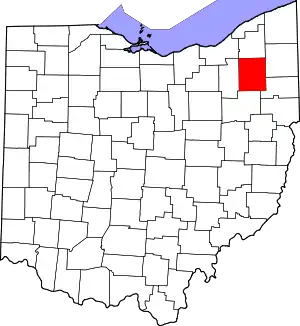 |
| Preble County | 135 | Eaton | Mar 1, 1808 | Montgomery and Butler Counties | Captain Edward Preble (1761–1807), a Naval commander in the Revolutionary War | 40,867 | 424.80 sq mi (1,100 km2) | 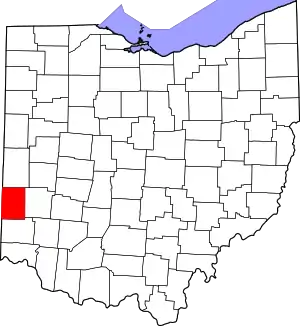 |
| Putnam County | 137 | Ottawa | Apr 1, 1820 | Shelby County | General Israel Putnam (1718–1790), a Revolutionary War officer | 34,318 | 483.87 sq mi (1,253 km2) | 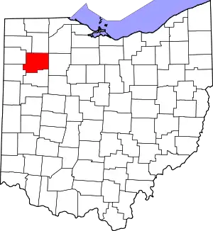 |
| Richland County | 139 | Mansfield | Mar 1, 1808 | Fairfield County | Descriptive of the soil in the area | 125,195 | 496.88 sq mi (1,287 km2) | 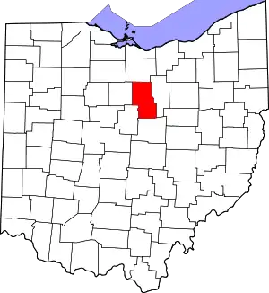 |
| Ross County | 141 | Chillicothe | Aug 20, 1798 | Adams and Washington Counties | Named for U.S. Senator from Pennsylvania James Ross by territorial governor Arthur St. Clair | 76,891 | 688.41 sq mi (1,783 km2) | 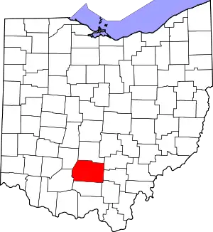 |
| Sandusky County | 143 | Fremont | Apr 1, 1820 | Huron County | An Iroquois word meaning "cold water" | 58,715 | 409.18 sq mi (1,060 km2) |  |
| Scioto County | 145 | Portsmouth | May 1, 1803 | Adams County | Scioto River; Scioto is a Wyandot Indian word meaning "deer" | 73,346 | 612.27 sq mi (1,586 km2) | 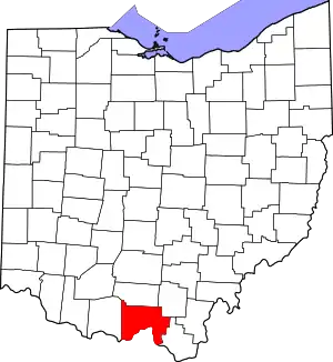 |
| Seneca County | 147 | Tiffin | Apr 1, 1820 | Huron County | Seneca Indians, who had a reservation in the county area at the time | 54,906 | 550.59 sq mi (1,426 km2) | 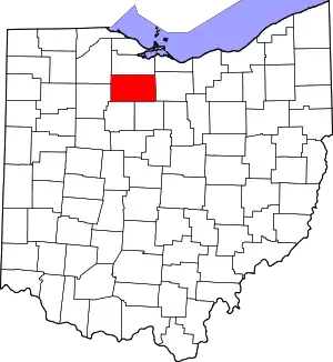 |
| Shelby County | 149 | Sidney | Apr 1, 1819 | Miami County | General Isaac Shelby (1750–1826), a Revolutionary War officer and Governor of Kentucky | 47,977 | 409.27 sq mi (1,060 km2) | 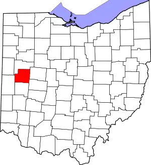 |
| Stark County | 151 | Canton | Feb 13, 1808 | Columbiana County | General John Stark (1728–1822), a Revolutionary War officer; known as the "Hero of Bennington" for his exemplary service at the Battle of Bennington in 1777 | 373,834 | 576.14 sq mi (1,492 km2) | 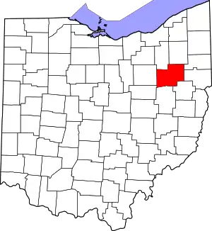 |
| Summit County | 153 | Akron | Mar 3, 1840 | Medina, Portage, and Stark Counties | Its location at the highest elevation along the Ohio and Erie Canal | 537,633 | 419.38 sq mi (1,086 km2) | 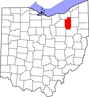 |
| Trumbull County | 155 | Warren | Jul 10, 1800 | Jefferson and Wayne Counties | Jonathan Trumbull (1710–1785), Governor of Connecticut when the county was organized | 201,335 | 616.48 sq mi (1,597 km2) | 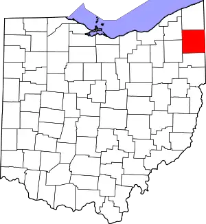 |
| Tuscarawas County | 157 | New Philadelphia | Mar 15, 1808 | Muskingum County | Tuscarawas River, meaning "open mouth river" or the Tuscarawas tribe who lived on the river |
92,500 | 567.58 sq mi (1,470 km2) | 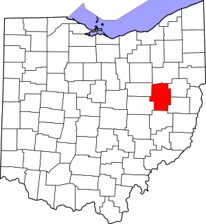 |
| Union County | 159 | Marysville | Apr 1, 1820 | Delaware, Franklin, Logan, and Madison Counties | Its formation by a union of four counties | 64,971 | 436.65 sq mi (1,131 km2) | 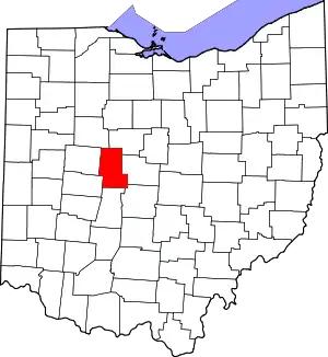 |
| Van Wert County | 161 | Van Wert | Apr 1, 1820 | Darke County | Isaac Van Wart (1760–1828), captor of spy John André during the Revolutionary War | 28,732 | 410.09 sq mi (1,062 km2) | 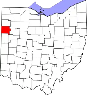 |
| Vinton County | 163 | McArthur | Mar 23, 1850 | Athens, Gallia, Hocking, Jackson, and Ross Counties | Samuel Finley Vinton (1792–1862), Ohio Statesman and U.S. Congressman | 12,696 | 414.08 sq mi (1,072 km2) | 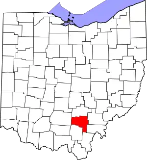 |
| Warren County | 165 | Lebanon | May 1, 1803 | Hamilton County | General Joseph Warren (1741–1775), a Revolutionary War officer | 246,553 | 399.63 sq mi (1,035 km2) | 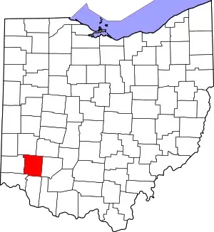 |
| Washington County | 167 | Marietta | Jul 27, 1788 | One of the original counties | George Washington (1732–1799), commander of the Continental Army, president of the Constitutional Convention, and future President of the United States | 59,423 | 635.15 sq mi (1,645 km2) | 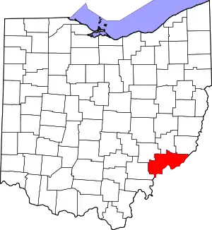 |
| Wayne County | 169 | Wooster | Mar 1, 1808 | From non-county area | General Anthony Wayne (1745–1796), a Revolutionary War officer | 116,710 | 555.36 sq mi (1,438 km2) | 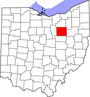 |
| Williams County | 171 | Bryan | Apr 1, 1820 | Darke County | David Williams (1754–1831), captor of spy John André during the Revolutionary War | 36,716 | 421.74 sq mi (1,092 km2) | 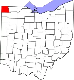 |
| Wood County | 173 | Bowling Green | Apr 1, 1820 | Refactored from non-county territory | Eleazer D. Wood (1783–1814), founder of Fort Meigs | 132,472 | 617.32 sq mi (1,599 km2) | 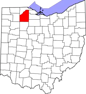 |
| Wyandot County | 175 | Upper Sandusky | Feb 3, 1845 | Marion, Crawford, and Hardin Counties | Wyandot Indians | 21,708 | 405.61 sq mi (1,051 km2) | 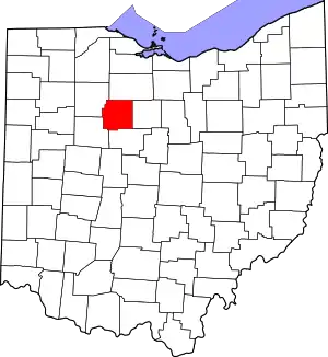 |
See also
- Ohio county government
- List of Ohio townships
- Illinois County, Virginia, the county that formerly covered all of present-day Ohio
References
- Laning, J.F. (1896). "The Evolution of Ohio Counties". Ohio Archaeological and Historical Publications. V: 326–350. Archived from the original on 2015-11-21.. Other editions available at ISBN 1249686741 and Google Books
- Lawyer, James Patterson (1905). History of Ohio: From the Glacial Period to the Present Time. Press of F. J. Heer. p. 381. Retrieved 2007-08-18.. Other editions available at ISBN 9781279183281
- Steinglass, Steven; Scarselli, Gino (2004). The Ohio State Constitution A Reference Guide. Westport, CT: Praeger Publishers. pp. 272–273. (OH county charter). Other editions available: ISBN 0313267650 and Google Books
- "County of Summit". Retrieved 2013-02-28.
- "Issue 6 reform wins big and sets in motion even bigger changes for Cuyahoga County". cleveland.com. 4 November 2009. Retrieved 2010-01-28.
- "OSBA - OSBA Staff Directory". www.ohiobar.org.
- "Title 3 - Ohio Revised Code | Ohio Laws".
- "Ohio QuickFacts". U.S. Census Bureau. Archived from the original on 2013-03-03. Retrieved 2013-02-27.
- "Population Estimates". U.S. Census Bureau. December 2009. Archived from the original on 2009-03-22. Retrieved 2013-02-27.
- "County FIPS Code Listing for the State of OHIO". United States Environmental Protection Agency. Retrieved 2016-07-09.
- "ODOT County Abbreviation Table" (PDF). Ohio Department of Transportation. May 1, 2013. Retrieved December 21, 2014.
- "Ohio Archaeological Inventory Form Instruction Manual" (PDF). Ohio Historic Preservation Office. June 2003. p. 61.
- "NACo - Find a County". Archived from the original on 2007-04-13. Retrieved 2007-07-22.
- "Federal Roster: Counties of Ohio, Derivation of Name and Date of Erection" (PDF). Archived from the original on 2013-07-12. Retrieved 2013-07-21.
{{cite web}}: CS1 maint: bot: original URL status unknown (link) - Howe, Henry (1891). Historical Collections of Ohio. Vol. 2. Columbus, OH: Henry Howe and Son. (OH county source). Other editions available: ISBN 1425565735 and Google Books
- 2020 census
- Resolution of 111th Ohio General Assembly designating John Allen as the person for which Allen County was named.
- Ashtabula, Encyclopædia Britannica, 2007. Accessed 2007-11-19.
- Cuyahoga River, Encyclopædia Britannica, 2007. Accessed 2007-11-19.
- About Fulton County
- Mahr, August C. (April 1957). "Indian River and Place Names in Ohio". Ohio Archaeological and Historical Quarterly. 66 (2): 146–148.
- Downes, p. 368.
- Taylor & Taylor, p. 40.
- "Noble County data". Ohio State University Extension Data Center. Archived from the original on 2008-02-13. Retrieved 2007-04-28.
Further reading
| Wikimedia Commons has media related to Counties of Ohio. |
- Downes, Randolph Chandler. "Evolution of Ohio County Boundaries". Ohio Archaeological and Historical Publications. 36: 340–477. Archived from the original on 2014-11-05.
- Taylor, William Alexander; Taylor, Aubrey Clarence (1899). Ohio statesmen and annals of progress: from the year 1788 to the year 1900 ... State of Ohio.
.svg.png.webp)