Cornwall (CDP), Connecticut
Cornwall is a census-designated place (CDP) comprising the central village in the town of Cornwall, Litchfield County, Connecticut, United States. It is in the geographic center of the town, along Connecticut Route 4 (Furnace Brook Road/Cemetery Hill Road), southeast of West Cornwall and northeast of Cornwall Bridge.
Cornwall, Connecticut | |
|---|---|
 Cornwall  Cornwall | |
| Coordinates: 41°50′37″N 73°19′47″W | |
| Country | |
| State | Connecticut |
| County | Litchfield |
| Town | Cornwall |
| Area | |
| • Total | 1.46 km2 (0.56 sq mi) |
| • Land | 1.46 km2 (0.56 sq mi) |
| • Water | 0.0 km2 (0.0 sq mi) |
| Elevation | 219 m (718 ft) |
| Time zone | UTC-5 (Eastern (EST)) |
| • Summer (DST) | UTC-4 (EDT) |
| ZIP Codes | |
| Area code(s) | 860/959 |
| FIPS code | 09-17170 |
| GNIS feature ID | 2805980[2] |
Cornwall was first listed as a CDP prior to the 2020 census.
References
- "2020 U.S. Gazetteer Files – Connecticut". United States Census Bureau. Retrieved April 12, 2021.
- "Cornwall Census Designated Place". Geographic Names Information System. United States Geological Survey.
Municipalities and communities of Litchfield County, Connecticut, United States | ||
|---|---|---|
| Consolidated city | 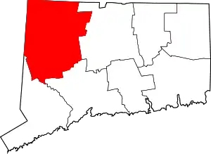 | |
| Towns | ||
| Boroughs | ||
| CDPs |
| |
| Other communities | ||
| Indian reservation | ||
| Footnotes | ‡This populated place also has portions in an adjacent county or counties. | |
| ||
This article is issued from Wikipedia. The text is licensed under Creative Commons - Attribution - Sharealike. Additional terms may apply for the media files.