China National Highway 217
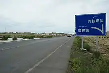
China National Highway 217 (G217) runs south from Altay, Xinjiang to Hotan, Xinjiang. It is 1,753 kilometres in length and runs southwest from Altay towards Kuqa County and from there southwards through the Taklamakan Desert to Hotan.
.svg.png.webp) | ||||
|---|---|---|---|---|
| 217国道 | ||||
 | ||||
| Route information | ||||
| Length | 1,753 km (1,089 mi) | |||
| Major junctions | ||||
| From | Altay, Xinjiang | |||
| To | Kuqa County, Xinjiang | |||
| Location | ||||
| Country | China | |||
| Highway system | ||||
| ||||
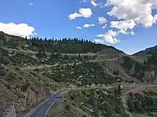
The section between Dushanzi and Kuqa crosses the Tianshan Mountains and is commonly known as Duku Highway (独库公路).
Route and distance
| Route and distance | ||||||||||||||||||||
|
Mountain Passes
From North to South:
- Haxilegen Pass, bypassed by tunnel. 3450 meters above the sea level.
- Yuximole Pass, bypassed by tunnel. 3438 meters above the sea level.
- Laerdun Pass. 2730 meters above the sea level.
- Tielimaiti Pass. bypassed by tunnel. 3335 meters above the sea level.
See also
External links
| Wikimedia Commons has media related to China National Highway 217. |
| Radial | |
|---|---|
| North–south | |
| East–west | |
| Extended plan in 2013 under construction/renovation |
|
| Major routes (Abolished and absorbed into NTHS) | |
| Note | China National Highway 112 runs around Beijing |