Châtonnay
Châtonnay (French pronunciation: [ʃatɔnɛ]) is a commune in the Isère department in southeastern France.
Châtonnay | |
|---|---|
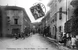 The church square in 1913 | |
Location of Châtonnay 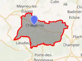 | |
 Châtonnay  Châtonnay | |
| Coordinates: 45°29′12″N 5°12′28″E | |
| Country | France |
| Region | Auvergne-Rhône-Alpes |
| Department | Isère |
| Arrondissement | Vienne |
| Canton | Bièvre |
| Government | |
| • Mayor (2020–2026) | Jean-Michel Nogueras[1] |
| Area 1 | 31.84 km2 (12.29 sq mi) |
| Population | 2,020 |
| • Density | 63/km2 (160/sq mi) |
| Time zone | UTC+01:00 (CET) |
| • Summer (DST) | UTC+02:00 (CEST) |
| INSEE/Postal code | 38094 /38440 |
| Elevation | 424–615 m (1,391–2,018 ft) (avg. 452 m or 1,483 ft) |
| 1 French Land Register data, which excludes lakes, ponds, glaciers > 1 km2 (0.386 sq mi or 247 acres) and river estuaries. | |
Population
|
|
See also
References
- "Répertoire national des élus: les maires". data.gouv.fr, Plateforme ouverte des données publiques françaises (in French). 9 August 2021.
- "Populations légales 2019". The National Institute of Statistics and Economic Studies. 29 December 2021.
| Wikimedia Commons has media related to Châtonnay. |
This article is issued from Wikipedia. The text is licensed under Creative Commons - Attribution - Sharealike. Additional terms may apply for the media files.