Mauléon, Deux-Sèvres
Mauléon (French pronunciation: [moleɔ̃]) is a commune in the Deux-Sèvres department, western France. It is around 20 km south-east of Cholet, and around 70 km south-east of Nantes.
Mauléon | |
|---|---|
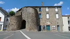 The old fortified gate, in Mauléon | |
.svg.png.webp) Coat of arms | |
Location of Mauléon 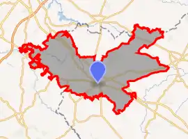 | |
 Mauléon  Mauléon | |
| Coordinates: 46°55′25″N 0°44′54″W | |
| Country | France |
| Region | Nouvelle-Aquitaine |
| Department | Deux-Sèvres |
| Arrondissement | Bressuire |
| Canton | Mauléon |
| Government | |
| • Mayor (2020–2026) | Pierre-Yves Marolleau[1] |
| Area 1 | 120.64 km2 (46.58 sq mi) |
| Population | 8,578 |
| • Density | 71/km2 (180/sq mi) |
| Time zone | UTC+01:00 (CET) |
| • Summer (DST) | UTC+02:00 (CEST) |
| INSEE/Postal code | 79079 /79700 |
| Elevation | 104–226 m (341–741 ft) (avg. 187 m or 614 ft) |
| 1 French Land Register data, which excludes lakes, ponds, glaciers > 1 km2 (0.386 sq mi or 247 acres) and river estuaries. | |
History
Mauléon was formed in 1965 by the merger of the two former communes of Châtillon-sur-Sèvre and Saint-Jouin-sous-Châtillon. The territory of the commune also includes the villages of La Chapelle-Largeau, Loublande, Moulins, Rorthais, Saint-Amand-sur-Sèvre, Saint-Aubin-de-Baubigné and Le Temple
References
- "Répertoire national des élus: les maires". data.gouv.fr, Plateforme ouverte des données publiques françaises (in French). 2 December 2020.
- "Populations légales 2019". The National Institute of Statistics and Economic Studies. 29 December 2021.
| Wikimedia Commons has media related to Mauléon (Deux-Sèvres). |
This article is issued from Wikipedia. The text is licensed under Creative Commons - Attribution - Sharealike. Additional terms may apply for the media files.