Château-Gaillard, Ain
Château-Gaillard (French pronunciation: [ʃɑto ɡajaʁ]) is a commune in the eastern French department of Ain.
Château-Gaillard | |
|---|---|
Commune | |
.JPG.webp) Town hall | |
.svg.png.webp) Coat of arms | |
Location of Château-Gaillard 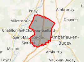 | |
 Château-Gaillard  Château-Gaillard | |
| Coordinates: 45°58′N 5°18′E | |
| Country | France |
| Region | Auvergne-Rhône-Alpes |
| Department | Ain |
| Arrondissement | Belley |
| Canton | Ambérieu-en-Bugey |
| Intercommunality | Plaine de l'Ain |
| Government | |
| • Mayor (2020–2026) | Joël Brunet[1] |
| Area 1 | 16.6 km2 (6.4 sq mi) |
| Population | 2,253 |
| • Density | 140/km2 (350/sq mi) |
| Time zone | UTC+01:00 (CET) |
| • Summer (DST) | UTC+02:00 (CEST) |
| INSEE/Postal code | 01089 /01500 |
| Elevation | 222–253 m (728–830 ft) (avg. 230 m or 750 ft) |
| 1 French Land Register data, which excludes lakes, ponds, glaciers > 1 km2 (0.386 sq mi or 247 acres) and river estuaries. | |
Geography
The river Albarine forms most of the commune's southern border.
Population
| Year | Pop. | ±% |
|---|---|---|
| 2004 | 1,605 | — |
| 2006 | 1,668 | +3.9% |
| 2007 | 1,704 | +2.2% |
| 2008 | 1,732 | +1.6% |
| 2009 | 1,760 | +1.6% |
| 2010 | 1,818 | +3.3% |
| 2011 | 1,830 | +0.7% |
| 2012 | 1,881 | +2.8% |
| 2013 | 1,940 | +3.1% |
| 2014 | 1,999 | +3.0% |
| 2015 | 2,053 | +2.7% |
| 2016 | 2,080 | +1.3% |
See also
References
- "Répertoire national des élus: les maires". data.gouv.fr, Plateforme ouverte des données publiques françaises (in French). 2 December 2020.
- "Populations légales 2019". The National Institute of Statistics and Economic Studies. 29 December 2021.
| Wikimedia Commons has media related to Château-Gaillard, Ain. |
This article is issued from Wikipedia. The text is licensed under Creative Commons - Attribution - Sharealike. Additional terms may apply for the media files.