Catalpa Canyon, New Mexico
Catalpa Canyon is a census-designated place (CDP) in McKinley County, New Mexico, United States. It was first listed as a CDP prior to the 2020 census.[2]
Catalpa Canyon, New Mexico | |
|---|---|
 Catalpa Canyon  Catalpa Canyon | |
| Coordinates: 35°29′24″N 108°43′38″W | |
| Country | United States |
| State | New Mexico |
| County | McKinley |
| Area | |
| • Total | 7.0 sq mi (18.2 km2) |
| • Land | 7.0 sq mi (18.2 km2) |
| • Water | 0.0 sq mi (0.0 km2) |
| Elevation | 6,780 ft (2,070 m) |
| Time zone | UTC-7 (Mountain (MST)) |
| • Summer (DST) | UTC-6 (MDT) |
| ZIP Code | 87301, 87305 (Gallup) |
| Area code(s) | 505 |
| FIPS code | 35-12844 |
| GNIS feature ID | 2806713[2] |
The community is in the western part of McKinley County, bordered to the north by the city of Gallup, the county seat. Catalpa Canyon is a valley in the center of the CDP that drains north to the Puerco River in the eastern part of Gallup.
New Mexico State Road 602 passes through the western part of the CDP, leading north into Gallup and south 15 miles (24 km) to Vanderwagen.
Education
It is in Gallup-McKinley County Public Schools.[3]
Most areas are zoned to Red Rock Elementary School, though some are zoned to Jefferson and Stagecoach elementaries. Most areas are zoned to Gallup Middle School, though some are zoned to Chief Manualito and John F. Kennedy middle schools. Most areas are zoned to Hiroshi Miyamura High School though some are zoned to Gallup High School.[4]
References
- "2020 U.S. Gazetteer Files – New Mexico". United States Census Bureau. Retrieved June 28, 2021.
- "Catalpa Canyon Census Designated Place". Geographic Names Information System. United States Geological Survey.
- "2020 CENSUS - SCHOOL DISTRICT REFERENCE MAP: McKinley County, NM" (PDF). U.S. Census Bureau. Retrieved 2021-07-20. - Compare with school district maps.
- "GMCS Address Lookup". Gallup-McKinley County Schools. Retrieved 2022-01-15. - KML files: Elementary boundaries and locations, Middle boundaries and locations, and High boundaries and locations.
Municipalities and communities of McKinley County, New Mexico, United States | ||
|---|---|---|
| City | 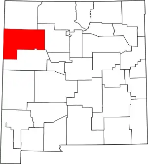 Map of New Mexico highlighting McKinley County | |
| CDPs |
| |
| Other communities | ||
| Indian reservation | ||
| Footnotes | ‡This populated place also has portions in an adjacent county or counties | |
| ||