Cappelle-en-Pévèle
Cappelle-en-Pévèle (French pronunciation: [kapɛl ɑ̃ pevɛl]) is a commune in the Nord department in northern France.
Cappelle-en-Pévèle | |
|---|---|
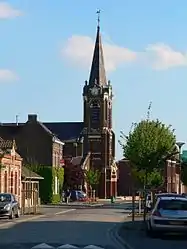 A general view of Cappelle-en-Pévèle | |
_Nord-France.svg.png.webp) Coat of arms | |
Location of Cappelle-en-Pévèle 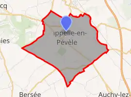 | |
 Cappelle-en-Pévèle  Cappelle-en-Pévèle | |
| Coordinates: 50°30′39″N 3°10′24″E | |
| Country | France |
| Region | Hauts-de-France |
| Department | Nord |
| Arrondissement | Lille |
| Canton | Templeuve |
| Intercommunality | Pévèle-Carembault |
| Government | |
| • Mayor (2020–2026) | Bernard Chocraux[1] |
| Area 1 | 8.11 km2 (3.13 sq mi) |
| Population | 2,268 |
| • Density | 280/km2 (720/sq mi) |
| Time zone | UTC+01:00 (CET) |
| • Summer (DST) | UTC+02:00 (CEST) |
| INSEE/Postal code | 59129 /59242 |
| Elevation | 34–56 m (112–184 ft) (avg. 44 m or 144 ft) |
| 1 French Land Register data, which excludes lakes, ponds, glaciers > 1 km2 (0.386 sq mi or 247 acres) and river estuaries. | |
Heraldry
Arms of Cappelle-en-Pévèle |
The arms of Cappelle-en-Pévèle are blazoned : Quarterly Or and gules. (Cappelle-en-Pévèle and Roucourt use the same arms.)
|
See also
References
- "Répertoire national des élus: les maires". data.gouv.fr, Plateforme ouverte des données publiques françaises (in French). 2 December 2020.
- "Populations légales 2019". The National Institute of Statistics and Economic Studies. 29 December 2021.
| Wikimedia Commons has media related to Cappelle-en-Pévèle. |
This article is issued from Wikipedia. The text is licensed under Creative Commons - Attribution - Sharealike. Additional terms may apply for the media files.