Cackleberry Airport
Cackleberry Airport (FAA LID: 2E8) is a privately owned, public use airport located five nautical miles (6 mi, 9 km) north of the central business district of Dexter, a village in Washtenaw County, Michigan, United States.[1]
Cackleberry Airport | |||||||||||
|---|---|---|---|---|---|---|---|---|---|---|---|
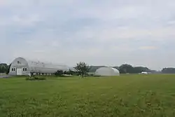 Hangar area | |||||||||||
| Summary | |||||||||||
| Airport type | Public | ||||||||||
| Owner | John Wiltse | ||||||||||
| Serves | Dexter, Michigan | ||||||||||
| Elevation AMSL | 890 ft / 271 m | ||||||||||
| Coordinates | 42°25′30″N 083°52′10″W | ||||||||||
| Runways | |||||||||||
| |||||||||||
| Statistics (2009) | |||||||||||
| |||||||||||
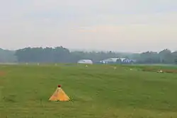
View from Hermitage Way
Facilities and aircraft
Cackleberry Airport covers an area of 40 acres (16 ha) at an elevation of 890 feet (271 m) above mean sea level. It has one runway designated 6/24 with a turf surface measuring 2,113 by 100 feet (644 x 30 m). For the 12-month period ending December 31, 2009, the airport had 100 general aviation aircraft operations.[1]
References
- FAA Airport Form 5010 for 2E8 PDF. Federal Aviation Administration. effective April 5, 2012.
External links
- "Cackleberry Airport (2E8)" (PDF). at the Michigan Airport Directory
- Aerial image as of April 1998 from USGS The National Map
- Cackleberry Airport on LocalWiki
- Resources for this airport:
- FAA airport information for 2E8
- AirNav airport information for 2E8
- FlightAware airport information and live flight tracker
- SkyVector aeronautical chart for 2E8
This article is issued from Wikipedia. The text is licensed under Creative Commons - Attribution - Sharealike. Additional terms may apply for the media files.