Britswert
Britswert (Dutch: Britswerd) is a small village in Súdwest-Fryslân municipality in the province of Friesland, the Netherlands. It had a population of around 112 in January 2017.[3]
Britswerd
Britswert | |
|---|---|
Village | |
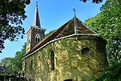 Britswert church | |
 Flag  Coat of arms | |
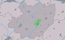 Location in the former Littenseradiel municipality | |
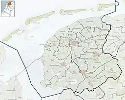 Britswerd Location in the Netherlands  Britswerd Britswerd (Netherlands) | |
| Coordinates: | |
| Country | |
| Province | |
| Municipality | |
| Area | |
| • Total | 4.26 km2 (1.64 sq mi) |
| Elevation | 0.2 m (0.7 ft) |
| Population (2021)[1] | |
| • Total | 105 |
| • Density | 25/km2 (64/sq mi) |
| Postal code | 8636[1] |
| Dialing code | 058 |
History
The village was first mentioned in the late-13th century as Bretsenewarth, and means "broken or split terp.[4] Britswert is a terp (artificial living hill) villages which was located between two lakes. The Britswerdermeer was finally poldered in 1885. The St Joris Church dates from the 12th century,[5] however it was restored after a fire in 1514, and the tower was rebuilt in 1889.[6][5] The village as home to both fishermen and farmers. Between 1200 and 1300, the Middelzee silted, and the village gradually became an agricultural community.[6]
Britswert was home to 120 people in 1840.[6] Before 2018, the village was part of the Littenseradiel municipality.[6]
Gallery
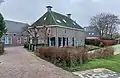 Houses in Britswert
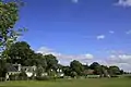 View on Britswert
References
- "Kerncijfers wijken en buurten 2021". Central Bureau of Statistics. Retrieved 5 April 2022.
- "Postcodetool for 8636VA". Actueel Hoogtebestand Nederland (in Dutch). Het Waterschapshuis. Retrieved 5 April 2022.
- Aantal inwoners per dorp Archived 2017-04-21 at the Wayback Machine - Littenseradiel
- "Britswert - (geografische naam)". Etymologiebank (in Dutch). Retrieved 5 April 2022.
- "Britswert". Friesland Wonderland (in Dutch). Retrieved 5 April 2022.
- "Britswert". Plaatsengids (in Dutch). Retrieved 5 April 2022.