Bellis, Alberta
Bellis is a hamlet in central Alberta, Canada within Smoky Lake County.[2] Previously an incorporated municipality, Bellis dissolved from village status on January 1, 1946 to become part of the Municipal District of Vilna No. 575.[3]
Bellis | |
|---|---|
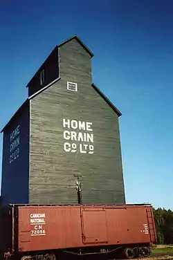 The Bellis Home Grain Co. Ltd. elevator, which was built in 1920, closed in 1972 and moved in 1980, is now located and preserved on display at the Ukrainian Cultural Heritage Village, east of Edmonton. | |
Bellis Location of Bellis  Bellis Bellis (Canada) | |
| Coordinates: 54°08′34″N 112°09′01″W | |
| Country | Canada |
| Province | Alberta |
| Region | Central Alberta |
| Census division | 12 |
| Municipal district | Smoky Lake County |
| Government | |
| • Type | Unincorporated |
| • Governing body | Smoky Lake County Council |
| Area (2021)[1] | |
| • Land | 0.23 km2 (0.09 sq mi) |
| Population (2021)[1] | |
| • Total | 60 |
| • Density | 258.6/km2 (670/sq mi) |
| Time zone | UTC−07:00 (MST) |
| • Summer (DST) | UTC−06:00 (MDT) |
| Area codes | 780, 587, 825 |
Bellis is located 8 kilometres (5.0 mi) west of Highway 36, approximately 111 kilometres (69 mi) northeast of Edmonton. The hamlet's name derives from the Ukrainian: Bel lis "white woods", referring to the local birch and poplars. The first settlers arrived in 1898.[4]
Demographics
In the 2021 Census of Population conducted by Statistics Canada, Bellis recorded a population of 60 living in 23 of its 33 total private dwellings, a change of 20% from its 2016 population of 50. With a land area of 0.23 km2 (0.089 sq mi), it had a population density of 260.9/km2 (675.6/sq mi) in 2021.[1]
As a designated place in the 2016 Census of Population conducted by Statistics Canada, Bellis recorded a population of 50 living in 19 of its 36 total private dwellings, a change of -7.4% from its 2011 population of 54. With a land area of 0.23 km2 (0.089 sq mi), it had a population density of 217.4/km2 (563.0/sq mi) in 2016.[5]
See also
References
- "Population and dwelling counts: Canada and designated places". Statistics Canada. February 9, 2022. Retrieved February 10, 2022.
- "Specialized and Rural Municipalities and Their Communities" (PDF). Alberta Municipal Affairs. January 12, 2022. Retrieved January 21, 2022.
- "Table 6a: Population by census divisions and subdivisions showing reorganization of rural areas, 1931-1946". Census of the Prairie Provinces, 1946. Vol. I: Population. Ottawa: Dominion Bureau of Statistics. 1949. p. 426.
- A century of progress : an historical study of the Waskatenau, Smoky Lake, Warspite, Bellis, Vilna and Spedden school communities. The County of Smoky Lake No. 13. 1967. p. 1. Archived from the original on March 3, 2017. Retrieved June 10, 2013.
- "Population and dwelling counts, for Canada, provinces and territories, and designated places, 2016 and 2011 censuses – 100% data (Alberta)". Statistics Canada. February 8, 2017. Retrieved February 13, 2017.