Beilin District, Suihua
Beilin (Chinese: 北林; pinyin: Běilín; lit. 'northern forest') is the only district of the city of Suihua, Heilongjiang, People's Republic of China.
Beilin
北林区 | |
|---|---|
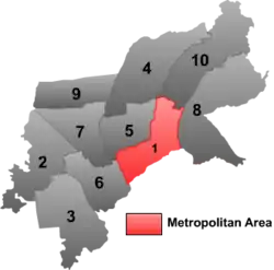 Beilin District (red) in Suihua City | |
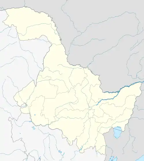 Beilin Location in Heilongjiang | |
| Coordinates (Beilin District government): 46°38′14″N 126°59′07″E | |
| Country | People's Republic of China |
| Province | Heilongjiang |
| Prefecture-level city | Suihua |
| Township-level divisions | 6 subdistricts 12 towns 8 townships |
| District seat | Zilai Subdistrict (紫来街道) |
| Area | |
| • Total | 359 km2 (139 sq mi) |
| Elevation | 173 m (568 ft) |
| Population (2018)[1] | |
| • Total | 813,016 |
| • Density | 2,300/km2 (5,900/sq mi) |
| Time zone | UTC+8 (China Standard) |
| Postal code | 152000 |
| Area code(s) | 0455 |
Administrative divisions
There are twelve subdistricts, 15 towns, and five townships in the district:[2][3]
Subdistricts
|
|
Towns
|
|
Townships
- Hongqi Manchu Ethnic Township (红旗满族乡)
- Liangang Township (连岗乡)
- Xinhua Township (新华乡)
- Wuying Township (五营乡)
- Xinghe Korean Ethnic Township (兴和朝鲜族县)
Notes and references
- 全国各县市区人口排名 www.hongheiku.com (in Chinese). hongheiku. Retrieved 2022-01-05.
- 2011年统计用区划代码和城乡划分代码:昂昂溪区 (in Chinese). National Bureau of Statistics of the People's Republic of China. Retrieved 2013-01-27.
- "国家统计局" (in Chinese). National Bureau of Statistics of the People's Republic of China. Retrieved 2021-12-07.
This article is issued from Wikipedia. The text is licensed under Creative Commons - Attribution - Sharealike. Additional terms may apply for the media files.