Beaver Valley, Arizona
Beaver Valley is a census-designated place in Gila County in the state of Arizona. Beaver Valley is located about 10 miles north of the town of Payson. The population as of the 2010 U.S. Census was 231.[2]
Beaver Valley, Arizona | |
|---|---|
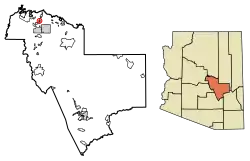 Location of Beaver Valley in Gila County, Arizona. | |
 Beaver Valley  Beaver Valley | |
| Coordinates: 34°20′27″N 111°17′55″W | |
| Country | United States |
| State | Arizona |
| County | Gila |
| Area | |
| • Total | 1.50 sq mi (3.90 km2) |
| • Land | 1.50 sq mi (3.89 km2) |
| • Water | 0.00 sq mi (0.00 km2) |
| Elevation | 4,954 ft (1,510 m) |
| Population (2020) | |
| • Total | 226 |
| • Density | 150.37/sq mi (58.04/km2) |
| Time zone | UTC-7 (Mountain (MST)) |
| Area code(s) | 928 |
| GNIS feature ID | 2582737 |
Geography
Beaver Valley is located at 34.342985°N 111.300023°W.
According to the U.S. Census Bureau, the community has an area of 1.504 square miles (3.90 km2); 1.503 square miles (3.89 km2) of its area is land, and 0.001 square miles (0.0026 km2) is water.[3]
Demographics
| Historical population | |||
|---|---|---|---|
| Census | Pop. | %± | |
| 2010 | 231 | — | |
| 2020 | 226 | −2.2% | |
| U.S. Decennial Census[4] | |||
Beaver Valley first appeared on the 2010 U.S. Census as a census-designated place (CDP).[5]
References
- "2020 U.S. Gazetteer Files". United States Census Bureau. Retrieved October 29, 2021.
- https://www.census.gov/2010census/popmap/ipmtext.php?fl=04:0405495
- "2010 Census Gazetteer Files: Places – Arizona". U.S. Census Bureau. Archived from the original on September 6, 2013. Retrieved July 16, 2014.
- "Census of Population and Housing". Census.gov. Retrieved June 4, 2016.
- ftp://ftp2.census.gov/library/publications/2012/dec/cph-1-4.pdf
Municipalities and communities of Gila County, Arizona, United States | ||
|---|---|---|
| City | 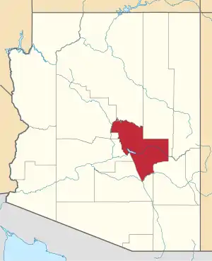 | |
| Towns | ||
| CDPs |
| |
| Populated places | ||
| Indian reservations | ||
| Ghost towns | ||
| Footnotes | ‡This populated place also has portions in an adjacent county or counties | |
| ||
This article is issued from Wikipedia. The text is licensed under Creative Commons - Attribution - Sharealike. Additional terms may apply for the media files.