Balally
Balally (Irish: Baile Amhlaoibh, meaning 'Olafs' Town'),[1] County Dublin, Ireland, is a townland and residential area between Dundrum village and the Sandyford Industrial Estate in Sandyford.
Balally
Baile Amhlaoibh | |
|---|---|
Suburb of Dublin | |
 Balally Location in Ireland | |
| Coordinates: 53°16′48″N 6°13′55″W | |
| Country | Ireland |
| Province | Leinster |
| County | County Dublin |
| Area | |
| • Total | 17 km2 (7 sq mi) |
| Time zone | UTC+0 (WET) |
| • Summer (DST) | UTC-1 (IST (WEST)) |
Balally Parish itself reaches from Ardglas to the M50 motorway. The area is served by two primary schools (St. Olaf's National School and Queen of Angels) and two secondary schools (St. Tiernan's and Wesley College). Balally is part of the conurbation of Greater Dublin, in the council area of Dún Laoghaire–Rathdown. The area contains a Luas tram station, located near the southern entrance to the new Dundrum Town Centre.
Name and location
Balally townland is in the civil parish of Taney in the barony of Rathdown.[1][2] The townland's Irish name, Baile Amhlaoibh, derives from a reputed associated with Olaf (Amhlaoibh), the first king of Viking Dublin, who built a fort in the locality. Baile Amhlaoibh, meaning "the town of Olaf", was anglicised as Balally.
Balally is located at the foot of the Wicklow Mountains and was originally farmland. It now includes several residential streets, including Balally Drive, Balally Hill, Balally Grove, Balally Close, Balally Park, Balally Avenue, Balally Road, and Sandyford Road. It is connected to Sandyford Road at Balally Hill.
Amenities
The local primary school, St. Olaf's National School,[3] had an enrollment of more than 480 pupils as of 2018.[4] The Church of the Ascension of the Lord, the local Roman Catholic church, was built in October 1982.[5]
Balally Residents Association has been in existence since 1964.[6]
Transport
Balally is served by bus route numbers 44, 44B and 116. The 44 travels on to Enniskerry in the south and Larkhill to the north and runs seven days a week. The 44B service operates on weekdays between Dundrum and Glencullen. The 116 also serves the area, as do Go-Ahead Ireland route numbers 75 (Tallaght/Dún Laoghaire) and 75A (Tallaght/Dún Laoghaire via Sandyford Business Park).
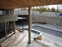
Balally Luas stop is a stop on the Luas light rail system. It connects the suburb to Brides Glen stop in the south and the city centre and Broombridge station in the North.
Some proposals for the Dublin Metro, also known as Metrolink, proposed a stop alongside Ballaly's Luas station on its way from Swords to Sandyford.[7] However, as of February 2019, it was questioned whether this section of the line would be completed as originally proposed.[8]
Sport
Naomh Olaf is the local Gaelic Athletic Association club and Balally Celtic is the local association football club.
References
- "Baile Amhlaoibh / Balally". logainm.ie. Placenames Database of Ireland. Retrieved 16 April 2022.
- "Balally Townland, Co. Dublin". townlands.ie. Retrieved 16 April 2022.
- "St. Olaf's National SchoolSt. Olaf's National School". homepage.eircom.net. Archived from the original on 21 February 2014. Retrieved 24 December 2021.
- "Curriculum Evaluation - Report - St Olaf's National School". gov.ie. Department of Education. 20 February 2018. Retrieved 16 April 2022.
- "History". Balally Parish. Archived from the original on 24 June 2011.
- "Balally Residents Association". Balally Residents Association. Archived from the original on 8 May 2021. Retrieved 24 December 2021.
- "Metrolink public consultation 2018" (PDF). Archived from the original (PDF) on 28 September 2020.
- "Southside section of MetroLink set to be abandoned". Irish Examiner. 21 February 2019. Archived from the original on 28 August 2021. Retrieved 24 December 2021.