Arzenc-de-Randon
Arzenc-de-Randon is a commune in the Lozère department in southern France.
Arzenc-de-Randon | |
|---|---|
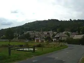 A general view of the village of Arzenc-de-Randon | |
 Coat of arms | |
Location of Arzenc-de-Randon 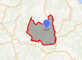 | |
 Arzenc-de-Randon  Arzenc-de-Randon | |
| Coordinates: 44°39′45″N 3°37′58″E | |
| Country | France |
| Region | Occitania |
| Department | Lozère |
| Arrondissement | Mende |
| Canton | Grandrieu |
| Intercommunality | CC Randon-Margeride |
| Government | |
| • Mayor (2020–2026) | Francis Gibert[1] |
| Area 1 | 69.20 km2 (26.72 sq mi) |
| Population | 193 |
| • Density | 2.8/km2 (7.2/sq mi) |
| Time zone | UTC+01:00 (CET) |
| • Summer (DST) | UTC+02:00 (CEST) |
| INSEE/Postal code | 48008 /48170 |
| Elevation | 1,146–1,542 m (3,760–5,059 ft) (avg. 1,189 m or 3,901 ft) |
| 1 French Land Register data, which excludes lakes, ponds, glaciers > 1 km2 (0.386 sq mi or 247 acres) and river estuaries. | |
Geography
The Chapeauroux flows east through the middle of the commune.
The Colagne has its source in the commune; with the Lac de Charpal they form most of the commune's southwestern border.
Population
|
|
See also
References
- "Répertoire national des élus: les maires". data.gouv.fr, Plateforme ouverte des données publiques françaises (in French). 2 December 2020. Retrieved 7 December 2020.
- "Populations légales 2019". The National Institute of Statistics and Economic Studies. 29 December 2021.
| Wikimedia Commons has media related to Arzenc-de-Randon. |
This article is issued from Wikipedia. The text is licensed under Creative Commons - Attribution - Sharealike. Additional terms may apply for the media files.