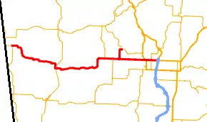
Arkansas Highway 102
Highway 102 (AR 102, Ark. 102, Hwy. 102) is an east–west state highway in Benton County, Arkansas. The highway connects several of western Benton County's population centers to Bentonville and Interstate 49 (I-49), the main north-south route in the Northwest Arkansas region. A single spur route runs north-south as Main Street in Centerton. Both highways are maintained by the Arkansas Department of Transportation (ArDOT).
 | ||||
|---|---|---|---|---|
 | ||||
| Route information | ||||
| Maintained by ArDOT | ||||
| Length | 26.184 mi[1] (42.139 km) | |||
| Existed | April 1, 1926[2]–present | |||
| Major junctions | ||||
| West end | ||||
| East end | ||||
| Location | ||||
| Country | United States | |||
| State | Arkansas | |||
| Counties | Benton | |||
| Highway system | ||||
| ||||
Route description
ArDOT maintains AR 102 as part of the state highway system. Including concurrencies, the highest traffic segment in 2021 was between Walton Boulevard and Greenhouse Road in Bentonville, with 36,000 vehicles per day on average. It remains over 30,000 VPD heading east from this segment, but drops as it travels west, with 14,000 VPD west of AR 102B, 3,900 west of Centerton, and 1,800 west of Decatur.[3]
The segment of Highway 102 between Walton Boulevard and I-49 is part of the National Highway System (NHS),[4][5] a network of roads important to the nation's economy, defense, and mobility.[6]
AR 102 begins in the northwestern corner of Arkansas, less than 10 miles (16 km) from the OKARMO Corner in Springfield Plateau of the Ozark Mountains. Beginning at a junction with AR 43, the route runs east through sparsely populated agricultural land, curving south to cross Spavinaw Creek before curving back east and running into the small town of Decatur. Upon entering Decatur, AR 102 intersects AR 59; the two routes form a short concurrency south as Main Street. The concurrency ends when AR 102 turns east onto Roller Avenue, with the highway exiting the city eastbound shortly thereafter. After passing through another rural section of Benton County, AR 102 curves to become a section line road entering Centerton, where it briefly overlaps AR 279 before becoming a main commercial thoroughfare known as Centerton Boulevard. AR 102 passes just north of the Centerton State Fish Hatchery and serves as the western terminus of its only business route, AR 102B (Main Street) near downtown Centerton.
East of this junction, AR 102B enters Bentonville, the county seat of Benton County, becoming known as 14th Street.[7] The highway passes through residential and commercial districts of Bentonville before crossing Walton Boulevard (former US 71 Business [US 71B]). Continuing east, AR 102 serves as the southern boundary of Walmart headquarters[8] before meeting Interstate 49/US Highway 62/US Highway 71 (I-49/US 62/US 71). The roadway continues east as US 62, toward Northwest Arkansas Community College and Rogers.[9]
History
Originally 102's east terminus was at U.S. 71 (now Highway 72) north of Centerton, but was extended to the intersection of Highway 94 and U.S. Route 62 (now U.S. Route 62 Business) in Rogers. After the opening of Interstate 49 the section east of 49 was replaced by US 62.
Major intersections
Mile markers reset at some concurrencies. The entire route is in Benton County.
| Location | mi[10][1] | km | Destinations | Notes | |
|---|---|---|---|---|---|
| | 0.000 | 0.000 | Western terminus | ||
| Decatur | 8.940 | 14.388 | West end of AR 59 concurrency | ||
| 0.000 | 0.000 | East end of AR 59 concurrency | |||
| Centerton | West end of AR 279 concurrency | ||||
| East end of AR 279 concurrency | |||||
| 11.364 | 18.289 | AR 102B western terminus | |||
| Bentonville | Walton Boulevard | Former US 71B | |||
| 17.244 | 27.752 | Eastern terminus, roadway continues east as US 62 | |||
1.000 mi = 1.609 km; 1.000 km = 0.621 mi
| |||||
Centerton business route
Highway 102B | |
|---|---|
| Location | Centerton |
| Length | 1.757 mi[1] (2.828 km) |
| Existed | July 1957–present |
Highway 102 Business (AR 102B, Ark. 102B, and Hwy. 102B) is a business route of 1.757 miles (2.828 km) in Centerton.[1] The route's southern terminus is at Highway 102 (Centerton Blvd) with its northern terminus at Highway 72 (SW 2nd St) southeast of Hiwasse.
- History
Originally part of the 1926 alignment of US 71, Highway 102B is also part of the original 1930's alignment of Highway 102.
- Major intersections
The entire route is in Benton County.
| Location | mi[1] | km | Destinations | Notes | |
|---|---|---|---|---|---|
| Centerton | 0.000 | 0.000 | Southern terminus | ||
| Bentonville | 1.757 | 2.828 | Northern terminus | ||
| 1.000 mi = 1.609 km; 1.000 km = 0.621 mi | |||||
See also
- Arkansas Highway 102 (1985–2007), former state highway in Rogers
References
- Transportation Planning and Policy Division (November 23, 2021). State Highway Route and Section Map, Benton County, Arkansas (PDF) (Map). 1:62,500. Little Rock: Arkansas Department of Transportation. Retrieved April 24, 2022.
- Arkansas State Highway Department (April 1, 1926). State of Arkansas Showing System of State Highways (TIF) (Map). 1:500,000. Little Rock: Arkansas State Highway Commission. Retrieved April 24, 2022 – via Arkansas GIS Office.
- System Information & Research Division (2021). Annual Average Daily Traffic Estimates (Map). Arkansas Department of Transportation. Retrieved April 24, 2022.
- System Information and Research Division (2016). "Arkansas Road Log Database" (MDB). Arkansas State Highway and Transportation Department. Retrieved June 13, 2017.
- Federal Highway Administration (October 1, 2020). National Highway System: Fayetteville--Springdale--Rogers, AR-MO (PDF) (Map). 1:190,080. U.S. Department of Transportation. Retrieved April 24, 2022.
- Natzke, Stefan; Neathery, Mike & Adderly, Kevin (June 29, 2017). "What is the National Highway System?". National Highway System. Federal Highway Administration. Retrieved July 15, 2018.
- Transportation Planning and Policy Division (February 2020). Map of Bentonville and Centerton, Benton County, Arkansas (PDF) (Map). 1:12,000. Little Rock: Arkansas Department of Transportation. §§ H1-H12. Retrieved April 24, 2022.
- McCall, Kayla (October 12, 2021). "Construction of new Walmart Campus Marches On". Arkansas Money & Politics. Little Rock: AY Media Group. Retrieved April 24, 2022.
- Planning and Research Division (November 10, 2021) [July 23, 2010]. General Highway Map, Benton County, Arkansas (PDF) (Map) (Revised ed.). 1:62500. Little Rock: Arkansas Department of Transportation. OCLC 908949212. Retrieved April 14, 2022.
- Arkansas Centerline File (GIS Map) (Map) (Updated ed.). Arkansas Department of Transformation and Shared Services. November 29, 2021 [September 29, 2014]. Retrieved April 14, 2022 – via GIS Office.
External links
![]() Media related to Arkansas Highway 102 at Wikimedia Commons
Media related to Arkansas Highway 102 at Wikimedia Commons