Early history of Ghana
Ghana was initially referred to as the Gold Coast. After attaining independence, the country's first sovereign government named the state after the Ghana Empire in modern Mauritania and Mali. Gold Coast was initially inhabited by different states, empires and ethnic groups before its colonization by the British Empire. The earliest known physical remains of the earliest man in Ghana were first discovered by archaeologists in a rock shelter at Kintampo during the 1960s. The remains were dated to be 5000 years old[1][2] and it marked the period of transition to sedentism in Ghana.[3] Early Ghanaians used Acheulean stone tools as hunter gatherers during the Early stone age. These stone tools evolved throughout the Middle and Late Stone Ages during which some early Ghanaians inhabited caves.
| History of Ghana |
|---|
| Timeline |
|
| By topic |
|
|
Sedentism was first established bewteen 2000 and 500 BC where crops such as Sorghum and millet were farmed. The earliest towns and cities generally arose by the 11th century. Some of these towns were located at strategic trade locations such as Begho on the Trans-Saharan trade route and Elmina a source of trade during the Atlantic slave trade. States were formed beginning in the 11th century with some of the earliest being the Kingdom of Dagbon and Bono. European contact with the Gold Coast begun in the 15th century with the Portuguese landing at the Coast. Several European states established colonies on portions of the Gold Coast. By the 20th century, the British Empire had colonized the entire region after annexing the Ashanti Empire in the War of the Golden Stool.
Prehistory
Early Stone Age
The oldest tools discovered by archaeologists in Ghana were found in the fossil gravels of the river Volta, Dayi, Oti and Birim. Others were found in a fossil marine beach at Asoprochona, near Tema. The oldest of these stone tools were large, heavy pearl shaped tools called Acheulean handaxes and U-shaped tools called Acheulian cleavers. These tools were used for hunting, food procurement and meat preparation.[1][4]
Middle Stone Age
Technology used by the Acheulian tool makers improved vastly in the Middle Stone Age period. Tools were reshaped for the production of axes, pick-axes, choppers, scrappers and hand axes. In the grassland of Northern Ghana, flake tools were produced and it included knives and arrowheads. The use of these new tools, to some extent relied on the environmental conditions which they found themselves. The improvement in man's tool making technique enabled the early stone age man to migrate from the Savannah region to the forest zone.[1] In the grassland and forest regions of middle and southern Ghana, the Sangoan cultural tradition prevailed as a result.[2]
Late Stone Age
There was innovation in the manufacturing of blade tools during this period that helped in the production of fishing and hunting equipment. Archaeology finds has established that Ghanaians during the late stone age period hunted for animals such as guinea pig, royal antelope, bear and chimpanzee through the use of traps and poisoned arrowheads. It was during the period that man established his home in caves and rocks.[5] Plants used in the preparation of food like the nettle tree, incense tree and the oil palm also survived in rock shelters and caves.[2]
First Settlers
Due to a lack of a writing system implemented during the Stone Age in Ghana, archaeologists have scanty knowledge of Stone Age farming in Ghana. Food production was borrowed from the Sahara and Sahel savannah regions. Excavations executed by Pre-historians which took place in the rock shelters of Kintampo and Hani in the Brong-Ahafo region, as well as at Ntereso, near Tamale, have presented evidence of farming activity during the stone age.[5] Between 2000 and 500 BC, pre-historic Ghanaians were believed to have reared dwarf goats, cattle and guinea fowls. They also collected yams and cowpeas. Indigenous food items in pre-colonial Ghana included sorghum, millet, West African rice, yellow and white yam, oil palm and shea butter.[6] The presence of fishing equipment such as harpoons proved that pre-historic Ghanaians also practiced fishing. Excavations have again revealed that since hunting equipment like polished arrowheads have been found, it was an evidence that hunting was another form of occupation during this period. Between 2000 BC and 500 Bc, pre-historic Ghanaians discarded the practiced of nomadism as well as living in caves and rock shelters, preferring to settle in villages.[4] Pre historic houses in Ghana were built with fossil mud, laterite blocks and stone blocks. The Wattle and daub architectural style which was famous among states such as the Ashanti Empire dates back to at least 6,000 years.[7] Examples of early Ghanaian homes include settlements discovered at the Boyase Hill, Nkukua Buoho, Hani in Brong Ahafo and at Gambaga in the Northern Region. The first farmers and settlers also made baked clay pottery or ceramic arts.[5] A stone axe or celt known locally as Nyame Dua was used by the settlers to fell trees, clear bushes and cultivate plants. The celt was usually cylindrical and shaped by using green stones called Calchlorite schist.[6]
Growth of Towns
Begho
Town development in pre-colonial Ghana begun around 1000 and 1700 AD. The first major towns that existed in pre-colonial Ghana included Begho, Bono Manso, Dawhenya and Elmina. The growth of these towns were influenced by factors such as their strategic location, economic and religious attractions, and the presence of large deposits of minerals such as gold and iron. Begho for example, developed due to its location on the Trans-Saharan trade route. By AD 1650, Begho had developed with a popuation of about 10,000 with varying ethnic groups from other regions such as Cote d'Ivoire and Mali. Archaeological evidence made available from Begho has established that the people had commercial contacts with the outside world early in their history. Imported goods excavated in Begho include goods of Dutch, Chinese, English Venetian and Egyptian origin.[8] Excavations have laid bare-walled structures dated between 1350 and 1750 AD, as well as pottery of all kinds, smoking pipes, and evidence of iron smelting. Begho was one of the largest towns in the southern part of West Africa at the time of the arrival of the Portuguese in 1471.[9]
Le and Se
Around 1300, small towns Le and Se also developed in Dawhenya and the Shai Hills. By 1650, Le had grown to a size that measured 1.6 kilometers by 1.1 kilometer, while Se grew to 9 kilometers by 2 kilometers. The region of which these towns developed lacked fertile lands for agricultural activities. It was instead, rich in Kaolin clay. This enabled the women of the area to use the kaolin clay to manufacture cooking pots, bowls, water jars, palm wine vessels and pots for brewing traditional medicine for people in the Accra plains, Akuapem and Shai. The abundance of kaolin clay attracted several migrants into the town which led to its growth. Between 1600 and 1750, the towns engaged in trade with both the local population and Europeans. Archaeological findings from the 17th century in these towns has revealed that the people of le and Se reared cattle, sheep, goats and fowls. [8]
Elmina
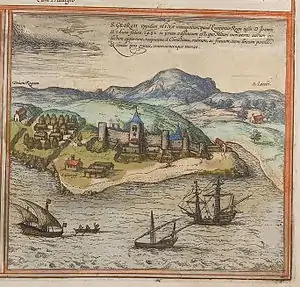
As a result of European presence and the development of the Trans Atlantic slave trade, Elmina grew to possess a population of over 2000 from the 15th and 16th centuries. The town was governed by a chief and council of elders whiles protected by a standing army. Early Portuguese writers like Joao de Barros and Pacheco Pereira described the 15th century settlement as a "Republican township" made up of several settlements. [8]
Kumasi
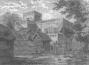
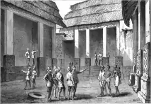
Kumasi was established by the first Ashanti king, Osei Kofi Tutu I along with state priest, Okomfo Anokye in the 17th century. It is on record that Kumasi was viewed as the most impressive town in the Gold Coast by visiting British officials largely as a result of its well designed buildings and organized roads. The city was the capital of the Ashanti Empire. Kumasi was located on two major trade routes; one from Mali and the other from Hausaland. This strategic location influenced its growth.[10]
Early States
Kingdom of Dagbon

According to oral history, the Kingdom of Dagbon was formed in the 11th century.[11] The people practiced a patrilineal system of inheritance. Trade was established with the Hausa states and Mali Empire. Islam was introduced into the kingdom between the 15th and 17th centuries by Mande and Soninke Muslim traders.[12]
Bono State
The Bono state grew powerful as a result of its location among the trade routes of the Trans Saharan trade. Its major city, Begho was of significance as an entrepot frequented by northern caravans from the Mali Empire around 1100 AD. Goods traded included ivory, salt, leather, gold, kola nuts, cloth, and copper alloys.[13][9]
Akwamu
Oral accounts place the formation of the Akwamu state between the 16th and 17th centuries. Akwamu established its capital at Asamankese where it expanded as a result of the lack of strong competition among its neighbors. By 1500, Akwamu was involved with gold trade among Europeans at Elmina.[14]
Denkyira
According to oral accounts, the Denkyira state was formed by migrants from the Bono state after its collapse. Initially, the state was a vassal to Adanse but it won its independence in a war against Adanse. The state embarked on expansionism by absorbing smaller groups such as the Ashanti, Sewhi, and Adanse.[14]
Ashanti Empire
The Ashanti Empire was formed from a union of various city states against the rule of Denkyira. Most of these states were initially tributaries of the Denkyira state. The Ashanti union became independent following its victory over Denkira at the Battle of Feyiase. By the 1680s, the Ashanti union had formed as a kingdom. Kumasi was also declared as the capital of this kingdom.[14] From the 18th century, the Ashanti embarked on an expansionist policy like the Denkyira, conquering a chunk of modern day Ghana as well as some parts of Ivory Coast and Togo.[15] By the 20th century, the Ashanti Empire was annexed by the British Empire after its defeat in the Anglo Ashanti war.[16][17]
Ga-Adangbe states
The Ga lived in scattered communities until the 17th century, where a kingdom emerged centered at Accra. Ayawaso became the capital of the kingdom of Accra whiles smaller settlements like Osu and Tema grew around the capital. Initially, the Ga-Adangbe did not have chiefs. Family heads pf various settlements which were grouped into quarters known as akutsei, were responsible for the welfare of the people. Real authority resided among the traditional priests. The Ga were later influenced by Akan chieftaincy institutions including the adoption of chiefs in their political system.[14]
Ewe states
Eweland was made up of 120 states by the 17th century. By the end of the century, some large states had emerged with the Anlo being the largest. Although the Ewe did not form a centralized kingdom, they cooperated in times of danger. These alliances were normally dissolved after the danger was resolved. In 1783, the Anlo came into conflict with the Danes where they were conquered into the Danish Empire. The Danes later sold their possessions in the Gold Coast to the British by 1850. The Anlo State became part of Southern Ghana when the British proclaimed the territory as a Crown Colony in 1874. Much of the other Ewelands were annexed by Germany following the Berlin Conference. In 1921, these areas were taken over by Britain as a mandated colony of the League of Nations.[14]
European colonies
Trade between the natives of Ghana and European states begun by the 15th century. In 1481, King John II of Portugal commissioned Diogo de Azambuja to build the Elmina Castle, which was completed in three years.[18] By 1598, the Dutch had joined the Portuguese in the gold trade, establishing the Dutch Gold Coast where they fortified their position at Komenda and Kormantsi.[19] In 1617, the Dutch captured the Olnini Castle from the Portuguese, along with Fort St Anthony in 1642.[19]
By the mid-17th century, other European traders had entered the gold trade with the natives of Gold Coast. Most notable among them were the Swedes, who established the Swedish Gold Coast, and Denmark-Norway, who established the Danish Gold Coast.[20] Because of the abandunce of gold in the area, Portuguese merchants named the region as Costa do Ouro or Gold Coast.[20] The Gold Coast was a strategic location during the Atlantic slave trade.[21] The Portuguese, Swedish, Dano-Norwegians, Dutch, and German traders erected more than thirty forts and castles in the region, with the last, Germans, establishing the German Gold Coast.[22]
In 1874, the British Empire took control of some areas of the country, naming them the British Gold Coast.[23] The British defeated the Ashanti in the War of the Golden Stool and by 1902, the entire of the Gold Coast region was a colony of Britain. [24][25]
References
- Prince A. Kuffour (2015), p. 171
- Seth K. Gadzekpo (2005), p. 7–12
- Casey, Joanna (2000). The Kintampo Complex: The Late Holocene on the Gambaga Escarpment, Northern Ghana. Archaeopress. ISBN 978-1-84171-202-4.
- Anquandah, James (2013). "The Peopling of Ghana: their cultures and origins". Transactions of the Historical Society of Ghana. 2 (15): 1–25. ISSN 0855-191X. JSTOR 43855009.
- Prince A. Kuffour (2015), p. 172
- Seth K. Gadzekpo (2005), p. 13
- Shaffer, Gary D. (Spring 1993). "An Archaeomagnetic Study of a Wattle and Daub Building Collapse". Journal of Field Archaeology. 20 (1): 59–75. JSTOR 530354.
- Prince A. Kuffour (2015), p. 173–174
- Goody, Jack (1964). "The Mande and the Akan Hinterland". In Vansina, J.; Mauny, R.; Thomas, L. V. (eds.). The Historian in Tropical Africa. London: Oxford University. pp. 192–218.
- Prince A. Kuffour (2015), p. 174
- Danver, Steven L. (2015-03-10). Native Peoples of the World: An Encyclopedia of Groups, Cultures and Contemporary Issues. Routledge. p. 25. ISBN 9781317464006.
- Seth K. Gadzekpo (2005), p. 29
- Crossland, L. B. (1989). Pottery from the Begho-B2 site, Ghana. African occasional papers. 4. Calgary: University of Calgary Press. ISBN 0-919813-84-4.
- Seth K. Gadzekpo (2005), p. 31-44
- Davidson, Basil (2014-10-29). West Africa before the Colonial Era: A History to 1850. Routledge. ISBN 978-1-317-88265-7.
- Puri, Jyoti (2008). Encountering Nationalism. Wiley. pp. 76–. ISBN 978-0-470-77672-8. Archived from the original on 15 September 2015. Retrieved 27 June 2015.
- Chronology of world history: a calendar of principal events from 3000 BC to AD 1973, Part 1973, Rowman & Littlefield, 1975, ISBN 0-87471-765-5.
- "History of Ghana". TonyX. Archived from the original on 1 May 2013. Retrieved 20 May 2012.
- Levy, Patricia; Wong, Winnie (2010). Ghana. Marshall Cavendish. p. 24. ISBN 978-0-7614-4847-1.
- "History of Ghana". ghanaweb.com. Archived from the original on 15 December 2010. Retrieved 10 January 2011.
- Emmer, Pieter C. (2018). The Dutch in the Atlantic Economy, 1580–1880: Trade, Slavery, and Emancipation (Variorum Collected Studies). Variorum Collected Studies (Book 614) (1st ed.). Abingdon-on-Thames: Routledge. p. 17. ISBN 978-0-86078-697-9.
- "Bush Praises Strong Leadership of Ghanaian President Kufuor". iipdigital.usembassy.gov. 15 September 2008. Archived from the original on 12 May 2014. Retrieved 26 June 2010.
- MacLean, Iain (2001) Rational Choice and British Politics: An Analysis of Rhetoric and Manipulation from Peel to Blair, p. 76, ISBN 0-19-829529-4.
- Ampene, Kwasi (2020-06-14), "Asante court music in historical perspective", Asante Court Music and Verbal Arts in Ghana, Routledge, pp. 34–63, doi:10.4324/9780429340628-2, ISBN 978-0-429-34062-8, S2CID 225687000
- McLaughlin & Owusu-Ansah (1994), Britain and the Gold Coast: the Early Years
Bibliography
- Prince A. Kuffour (2015). Concise Notes on African and Ghanaian History. K4 Series Investment Ventures. ISBN 9789988159306. Retrieved 2020-12-16 – via Books.google.com.
- Seth K. Gadzekpo (2005). History of Ghana: Since Pre-history. Excellent Pub. and Print. ISBN 9988070810. Retrieved 2020-12-27 – via Books.google.com.