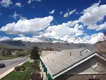
Alpine, Utah
Alpine is a city on the northeastern edge of Utah County, Utah. The population was 10,251 at the time of the 2020 census. Alpine has been one of the many quickly-growing cities of Utah since the 1970s, and especially the 1990s. This city is thirty-two miles southeast from Salt Lake City. It is located on the slopes of the Wasatch Range north of Highland and American Fork. The west side of the city runs above the Wasatch Fault.[5]
Alpine, Utah | |
|---|---|
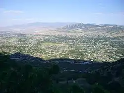 Overlooking Alpine | |
 Location in Utah County and the state of Utah | |
 Alpine, Utah Location in the United States | |
| Coordinates: 40°27′23″N 111°46′25″W[1] | |
| Country | United States |
| State | Utah |
| County | Utah |
| Settled | 1850 |
| Incorporated | January 19, 1855 |
| Area | |
| • Total | 7.96 sq mi (20.60 km2) |
| • Land | 7.96 sq mi (20.60 km2) |
| • Water | 0.00 sq mi (0.00 km2) |
| Elevation | 4,951 ft (1,509 m) |
| Population (2020) | |
| • Total | 10,251 |
| • Density | 1,319.67/sq mi (509.55/km2) |
| Time zone | UTC-7 (MST) |
| • Summer (DST) | UTC-6 (MDT) |
| ZIP code | 84004 |
| Area codes | 385, 801 |
| FIPS code | 49-00540[3] |
| GNIS feature ID | 1438174[4] |
| Website | City of Alpine |
History
The area which would one day become Alpine was settled by William Wordsworth and several other homesteading families in the fall of 1850.[6] The town was originally called Mountainville, and under the latter name settlement was first made in 1851.[7] The city was renamed because the views from the elevated town site were compared to the Swiss Alps.[8]
Geography
Alpine is located on State Route 74, just north of the city of Highland.
According to the United States Census Bureau, the city has a total area of 7.4 square miles (19.2 km2). None of that area is covered with water, although a number of small mountain streams run through the city on years with sufficient rainfall.
There are a number of mountain biking trails around the city that attract bikers from all over the state. There are also many trails and paths well suited for back-trail hiking along the mountains. The nearby American Fork Canyon offers camping, swimming and access to mountaineering regions around Mount Timpanogos.
The hills surrounding Alpine have been affected by a number of brush fires in recent years, the most devastating of which was the Quail Fire,[9] which consumed over 2200 acres on the north-east side of town in July 2012. The area is serviced by the Lone Peak Fire Department and Lone Peak Police Force.
Demographics
| Historical population | |||
|---|---|---|---|
| Census | Pop. | %± | |
| 1860 | 135 | — | |
| 1870 | 208 | 54.1% | |
| 1880 | 319 | 53.4% | |
| 1890 | 466 | 46.1% | |
| 1900 | 520 | 11.6% | |
| 1910 | 585 | 12.5% | |
| 1920 | 470 | −19.7% | |
| 1930 | 509 | 8.3% | |
| 1940 | 444 | −12.8% | |
| 1950 | 571 | 28.6% | |
| 1960 | 775 | 35.7% | |
| 1970 | 1,047 | 35.1% | |
| 1980 | 2,649 | 153.0% | |
| 1990 | 3,492 | 31.8% | |
| 2000 | 7,146 | 104.6% | |
| 2010 | 9,555 | 33.7% | |
| 2020 | 10,251 | 7.3% | |
| U.S. Decennial Census[10] | |||
[11][12][13][14] Alpine is part of the Provo–Orem metropolitan area.
As of the 2020 United States Census, there were 10,251 people, 1,662 households, and 1,545 families residing in the city.[3] The population density was 1,319.67 people per square mile (383.2/km2). There were 2,804 housing units at an average density of 240.7 per square mile (93.0/km2). The racial makeup of the city was 96.40% White, 0.1% African American, 0.4% Native American, 0.5% Asian, 0.0% Pacific Islander, 2% from other races, and 1.41% from two or more races. Hispanic or Latino of any race were 1.60% of the population.
There were 1,662 households, out of which 63.7% had children under the age of 18 living with them, 86.5% were married couples living together, 4.9% had a female householder with no husband present, and 7.0% were non-families. 6.3% of all households were made up of individuals, and 3.1% had someone living alone who was 65 years of age or older. The average household size was 4.30 and the average family size was 4.51.
In the city, the population was spread out, with 34.9% under the age of 18, 9.4% from 18 to 24, 23.3% from 25 to 44, 17.0% from 45 to 64, and 11.6% who were 65 years of age or older. The median age was 21 years. For every 100 females, there were 101.3 males. For every 100 females age 18 and over, there were 99.7 males.
The median income for a household in the city was $129,239, and the median income for a family was $74,891. Males had a median income of $57,250 versus $33,571 for females. The per capita income for the city was $45,352. About 3.5% of families and 3.6% of the population were below the poverty line, including 3.1% of those under age 18 and 9.1% of those age 65 or over.
Government
The mayor of Alpine is Carla Merrill. The members of the City Council are Jessica Smuin, Lon Lott, Kelli Law, Jason Thelin, and Greg Gordon. Alpine City Hall, located at the intersection of Main St. and Center St, celebrated the 80th anniversary of its construction in 2016.
Alpine is part of Utah's 3rd congressional district, represented by Republican John Curtis.[15]
Education
Despite being a fairly small town geographically, Alpine is home to five schools. Three of the schools are a part of the Alpine School District, while the fourth, Mountainville Academy, is a charter school for grades K-9. Alpine Elementary and Westfield Elementary are Alpine District Schools for grades K-6. Both of the Alpine District elementary schools feed into Timberline Middle School, a 7–9 grade school. The Montessori Canyon Academy was founded by Michelle Kerr in 2014, and offers private preschool education.[16]
Points of interest
- Burgess Park
- Creekside Park (100 South Park)
- Historic Moyle Park
- Horsetail Falls (Dry Creek Trail)
- Petersen Arboretum
- Sliding Rock
- American Fork Canyon (Alpine Scenic Highway)
- Tibble Fork Reservoir and Silver Lake Flat
Notable people
- William Grant Bangerter, religious authority
- Julie B. Beck, president of Relief Society 2007-12
- Jason Chaffetz, former congressman
- Frank Jackson, Duke and NBA basketball player
- Mike Kennedy, state representative and 2018 Utah senate candidate
- Rick Koerber, convicted fraudster[17]
- Mike Lee, U.S. senator
- Bronco Mendenhall, Virginia Cavaliers football coach
- Dale Murphy, former MLB player
- Lloyd Newell, speaker for the Mormon Tabernacle Choir
- Orrin Olsen, BYU and NFL football player
- May Booth Talmage, Relief Society overseer
- Celestia Taylor, BYU professor
- The 5 Browns, classical music group
- Josh James, founder of Domo and the former Omniture
- Lee Johnson, former NFL player
See also
References
- "US Gazetteer files: 2010, 2000, and 1990". United States Census Bureau. 2011-02-12. Retrieved 2011-04-23.
- "2019 U.S. Gazetteer Files". United States Census Bureau. Retrieved August 7, 2020.
- "U.S. Census website". United States Census Bureau. Retrieved 2008-01-31.
- "US Board on Geographic Names". United States Geological Survey. 2007-10-25. Retrieved 2008-01-31.
- "The Wasatch Fault from Above – Utah Geological Survey". Retrieved 2019-05-15.
- "Alpine City History". City of Alpine. Retrieved 2019-05-15.
- The Utah Genealogical and Historical Magazine, Volumes 9-10. 1918. p. 9.
- Leigh, Rufus Wood (1961). Five hundred Utah place names. Salt Lake City: Deseret News Press. p. 1.
- "Quail Fire 95 percent contained". 3 July 2012.
- "Census of Population and Housing". Census.gov. Retrieved June 4, 2015.
- "U.S. Census website". United States Census Bureau. Retrieved 2013-09-17.
- "Archived copy" (PDF). Archived from the original (PDF) on 2018-10-03. Retrieved 2014-03-15.
{{cite web}}: CS1 maint: archived copy as title (link) - "Population". U.S. Government Printing Office. 14 June 2019 – via Google Books.
- "U.S. Census website". United States Census Bureau. Retrieved 2015-06-04.
- "Alpine, Utah Politics & Voting". www.bestplaces.net. Retrieved 2019-05-15.
- "Montessori Canyon Academy". Montessori Canyon Academy.
- Emily Morton (2010-01-27). Alpine businessman Claud 'Rick' Koerber carries on despite Ponzi scheme charges. The Deseret News, accessed 2021-04-07
External links
![]() Media related to Alpine, Utah at Wikimedia Commons
Media related to Alpine, Utah at Wikimedia Commons
Places adjacent to Alpine, Utah | |
|---|---|
Municipalities and communities of Utah County, Utah, United States | ||
|---|---|---|
| Cities | 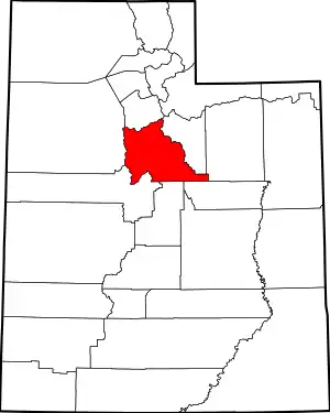 Map of Utah highlighting Utah County | |
| Towns | ||
| CDPs | ||
| Other communities | ||
| Indian reservation | ||
| Ghost towns | ||
| Footnotes | ‡This populated place also has portions in an adjacent county or counties | |
| ||