Lenawee County, Michigan
Lenawee County (/ˈlɛnʌweɪ/ LEN-uh-way) is a county located in the U.S. state of Michigan. As of the 2020 United States Census, the population was 99,423.[2] The county seat is Adrian.[3] The county was created in 1822, from territory partitioned from Monroe County. Its governing structure was organized in 1826.[1]
Lenawee County | |
|---|---|
.jpg.webp) | |
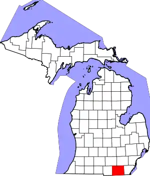 Location within the U.S. state of Michigan | |
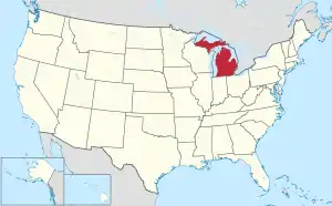 Michigan's location within the U.S. | |
| Coordinates: 41°53′N 84°04′W | |
| Country | |
| State | |
| Founded | 1822 (created) September 10, 1826 (organized)[1] |
| Seat | Adrian |
| Largest city | Adrian |
| Area | |
| • Total | 761 sq mi (1,970 km2) |
| • Land | 750 sq mi (1,900 km2) |
| • Water | 12 sq mi (30 km2) 1.6%% |
| Population (2020) | |
| • Total | 99,423 |
| • Density | 130/sq mi (51/km2) |
| Time zone | UTC−5 (Eastern) |
| • Summer (DST) | UTC−4 (EDT) |
| Congressional district | 7th |
| Website | www |
Lenawee County comprises the Adrian, MI Micropolitan Statistical Area and is included in the Detroit-Warren-Ann Arbor, MI Combined Statistical Area. It is served by the Toledo Media market.
Lenawee County is home to the Potawatomi, Ottawa, Chippewa, Iroquois, Miami, Sauk, Fox, Mascoutens and Huron tribes.[4]
History
The county owes its formation to the 1807 Treaty of Detroit, which ceded the Ottawa, Chippewa, Wyandot and Potawatomi nations' claim to today's southeast Michigan land to the United States.[5] However, this treaty was seen as quite coercive and benefited the United States over Indigenous nations, resulting in opposition from indigenous nations. This became part of the War of 1812 between the United States and indigenous nations. During this time, the Battle of Tippecanoe, the Battle of Lake Erie, and the Battle of Thames took place.[6] The United States won the Battle of the Thames, defeating the indigenous confederacy led by Chief Tecumseh, after which the city of the same name in Lenawee County is named. This battle results in the peace treaty, the Treaty of Ghent, which ends the war and solidifies ownership of the land demarcated in the Treaty of Detroit of the future state of Michigan, housing Lenawee County, to the United States.[6] Later in 1830, the Indian Removal Act signed by President Andrew Jackson, forcibly removed Indigenous peoples in Michigan from their homes and moved them to federal territory west of Mississippi, benefitting residents of Lenawee County to this day, at the expense of the Indigenous population in America.[7][8]

The county was organized in 1826, after being authorized and described by the Michigan legislature in 1822. It was taken from Monroe County, Michigan.[1] The county's name was a neologism created by Henry Schoolcraft, a "US Indian agent" in this region and proponent of forced Indigenous assimilation, responsible for the naming of several newly created counties in the area.[9] 'Lenawee' is thought to be derived from and an misappropriation of an Indigenous word, with some debate as to whether its origins lie in the Delaware leno or lenno, meaning "male," or the Shawnee lenawai.[1][10]
Geography
According to the US Census Bureau, the county has a total area of 761 square miles (1,970 km2), of which 750 square miles (1,900 km2) is land and 12 square miles (31 km2) (1.6%) is water.[11] Lenawee County is considered to be part of Southeastern Michigan.
Adjacent counties
- Jackson County, northwest
- Washtenaw County, northeast
- Monroe County, east
- Lucas County, Ohio, southeast
- Fulton County, Ohio, southwest
- Hillsdale County, west
Demographics
| Historical population | |||
|---|---|---|---|
| Census | Pop. | %± | |
| 1830 | 1,491 | — | |
| 1840 | 17,889 | 1,099.8% | |
| 1850 | 26,372 | 47.4% | |
| 1860 | 38,112 | 44.5% | |
| 1870 | 45,595 | 19.6% | |
| 1880 | 48,343 | 6.0% | |
| 1890 | 48,448 | 0.2% | |
| 1900 | 48,406 | −0.1% | |
| 1910 | 47,907 | −1.0% | |
| 1920 | 47,767 | −0.3% | |
| 1930 | 49,849 | 4.4% | |
| 1940 | 53,110 | 6.5% | |
| 1950 | 64,629 | 21.7% | |
| 1960 | 77,789 | 20.4% | |
| 1970 | 81,609 | 4.9% | |
| 1980 | 89,948 | 10.2% | |
| 1990 | 91,476 | 1.7% | |
| 2000 | 98,890 | 8.1% | |
| 2010 | 99,892 | 1.0% | |
| 2020 | 99,423 | −0.5% | |
| US Decennial Census[12] 1790-1960[13] 1900-1990[14] 1990-2000[15] 2010-2018[2] | |||
As of the 2000 United States Census, there were 98,890 people, 35,930 households, and 26,049 families in the county. The population density was 132 people per square mile (51/km2). There were 39,769 housing units at an average density of 53 per square mile (20/km2). The racial makeup of the county was 92.51% White, 2.12% Black or African American, 0.41% Native American, 0.46% Asian, 0.01% Pacific Islander, 3.01% from other races, and 1.49% from two or more races. 6.96% of the population were Hispanic or Latino of any race. Residents identified as being 30.4% of German, 11.6% English, 10.2% American and 9.9% Irish ancestry. Some 94.7% spoke English and 4.2% Spanish as their first language.
There were 35,930 households, out of which 34.20% had children under the age of 18 living with them, 58.70% were married couples living together, 10.00% had a female householder with no husband present, and 27.50% were non-families. 22.90% of all households were made up of individuals, and 9.70% had someone living alone who was 65 years of age or older. The average household size was 2.61 and the average family size was 3.07.
The county population contained 25.90% under the age of 18, 9.10% from 18 to 24, 28.60% from 25 to 44, 23.70% from 45 to 64, and 12.70% who were 65 years of age or older. The median age was 36 years. For every 100 females there were 100.10 males. For every 100 females age 18 and over, there were 98.00 males.
The median income for a household in the county was $45,739, and the median income for a family was $53,661. Males had a median income of $38,458 versus $25,510 for females. The per capita income for the county was $20,186. About 4.40% of families and 6.70% of the population were below the poverty line, including 7.10% of those under age 18 and 9.20% of those age 65 or over.
Government and politics
Lenawee County has been reliably Republican in national elections. Since 1884, its voters have selected the Republican Party nominee in 85% (29 of 34) of the national elections through 2016.
| Year | Republican | Democratic | Third party | |||
|---|---|---|---|---|---|---|
| No. | % | No. | % | No. | % | |
| 2020 | 31,541 | 59.01% | 20,918 | 39.13% | 993 | 1.86% |
| 2016 | 26,430 | 57.09% | 16,750 | 36.18% | 3,118 | 6.73% |
| 2012 | 22,351 | 49.75% | 21,776 | 48.47% | 801 | 1.78% |
| 2008 | 22,225 | 46.43% | 24,640 | 51.48% | 1,000 | 2.09% |
| 2004 | 25,675 | 54.61% | 20,787 | 44.22% | 550 | 1.17% |
| 2000 | 20,681 | 51.58% | 18,365 | 45.81% | 1,047 | 2.61% |
| 1996 | 14,168 | 39.78% | 16,924 | 47.51% | 4,527 | 12.71% |
| 1992 | 14,297 | 36.32% | 15,399 | 39.12% | 9,669 | 24.56% |
| 1988 | 19,115 | 57.84% | 13,690 | 41.42% | 243 | 0.74% |
| 1984 | 22,409 | 66.70% | 11,012 | 32.78% | 176 | 0.52% |
| 1980 | 20,366 | 56.44% | 12,935 | 35.85% | 2,784 | 7.72% |
| 1976 | 18,397 | 55.02% | 14,610 | 43.70% | 428 | 1.28% |
| 1972 | 19,125 | 62.39% | 11,018 | 35.94% | 511 | 1.67% |
| 1968 | 16,280 | 55.85% | 10,552 | 36.20% | 2,315 | 7.94% |
| 1964 | 11,385 | 40.29% | 16,815 | 59.50% | 60 | 0.21% |
| 1960 | 19,859 | 64.65% | 10,785 | 35.11% | 75 | 0.24% |
| 1956 | 21,100 | 72.68% | 7,857 | 27.06% | 74 | 0.25% |
| 1952 | 20,035 | 72.72% | 7,397 | 26.85% | 117 | 0.42% |
| 1948 | 14,369 | 67.49% | 6,529 | 30.67% | 393 | 1.85% |
| 1944 | 16,382 | 70.48% | 6,750 | 29.04% | 111 | 0.48% |
| 1940 | 16,963 | 70.19% | 7,132 | 29.51% | 71 | 0.29% |
| 1936 | 12,154 | 56.70% | 8,299 | 38.72% | 982 | 4.58% |
| 1932 | 10,912 | 50.50% | 10,420 | 48.23% | 275 | 1.27% |
| 1928 | 14,794 | 76.94% | 4,321 | 22.47% | 112 | 0.58% |
| 1924 | 13,358 | 72.65% | 3,950 | 21.48% | 1,080 | 5.87% |
| 1920 | 11,973 | 68.89% | 5,095 | 29.32% | 311 | 1.79% |
| 1916 | 6,247 | 52.01% | 5,519 | 45.95% | 246 | 2.05% |
| 1912 | 2,996 | 27.02% | 4,239 | 38.23% | 3,854 | 34.76% |
| 1908 | 6,607 | 56.22% | 4,704 | 40.03% | 441 | 3.75% |
| 1904 | 7,891 | 67.40% | 3,334 | 28.48% | 482 | 4.12% |
| 1900 | 6,847 | 51.75% | 5,966 | 45.09% | 419 | 3.17% |
| 1896 | 6,863 | 50.89% | 6,300 | 46.72% | 323 | 2.40% |
| 1892 | 5,833 | 46.86% | 5,592 | 44.92% | 1,024 | 8.23% |
| 1888 | 6,475 | 49.49% | 5,671 | 43.35% | 937 | 7.16% |
| 1884 | 5,827 | 46.63% | 5,572 | 44.59% | 1,098 | 8.79% |
The county government operates the jail, maintains rural roads, operates the major local courts, records deeds, mortgages, and vital records, administers public health regulations, and participates with the state in the provision of social services. The county board of commissioners controls the budget and has limited authority to make laws or ordinances. In Michigan, most local government functions—police and fire, building and zoning, tax assessment, street maintenance, etc.—are the responsibility of individual cities and townships.
Adrian College and Siena Heights University are located within the county.
Lenawee County has supported candidates from both political parties in statewide elections, making it a swing county. Tecumseh and Adrian have tended to lean Democrat, while Dover, Madison, and Riga Townships have tended to lean Republican. The rural areas of the county are bastions of populism and libertarianism which helped the Tea Party Movement gain considerable support. During the 2010 midterm elections, the county favored Republican Gubernatorial candidate Rick Snyder, Congressional candidate Tim Walberg, State Senate candidate Bruce Caswell, and State Representative candidates Nancy Jenkins and Mike Shirkey.
Lenawee County is located in Michigan's 7th congressional district, which is represented by Tim Walberg, who is a resident of the county. Walberg previously served as Lenawee's state representative. Backed by the Tea Party, Walberg won the district, which includes all of Lenawee County, Jackson County, Hillsdale County, Branch County, and Eaton County, as well as parts of Calhoun County and Washtenaw County. He defeated incumbent Democrat Mark Schauer. Schauer had defeated Walberg in the 2008 congressional election, after Walberg's first stint in Congress.
Most of Lenawee County is represented by Republican Bronna Kahle in the Michigan House of Representatives. Kahle represents the 57th District, previously represented by Republican Nancy Jenkins. She was preceded successively by brothers Doug and Dudley Spade, both Democrats.
Cambridge Township, which includes Onsted, is part of the 65th District, which covers much of the Irish Hills and is represented by Republican Mike Shirkey. Adrian is part of the 17th Senate District, represented by Dale Zorn of Ida, Michigan. Until the 2014 state senate election, Lenawee County was part of the 16th State Senate District, represented by Republican Bruce Caswell. The district contained all of Lenawee, Hillsdale, and Branch Counties.
Elected officials
- Prosecuting Attorney: R. Burke Castleberry Jr. (R)
- Sheriff: Troy Bevier (R)
- County Clerk: Roxann Holloway (R)
- County Treasurer: Erin Van Dyke (R)
- Register of Deeds: Carolyn S. Bater (R)
- Drain Commissioner: Jennifer Escott (R)
- County Surveyor: Kevin Pickford (R)
Current as of February 26, 2022 [17]
County Commission
- District 1: David Stimpson (R)
- District 2: Dustin Krasny (R)
- District 3: Nancy Jenkins-Arno (R)
- District 4: Dawn Bales (R)
- District 5: Karol "Kz" Bolton (D)
- District 6: Terry Collins (R)
- District 7: James Goetz (R)
- District 8: Ralph Tillotson (R)
- District 9: Chris Wittenbach (R)
County
- Lenawee County Sheriff's Office
City/Village
- Adrian City Police
- Blissfield Police
- Clinton Police
- Hudson Police
- Morenci Police
- Tecumseh Police
Township
- Adrian Township Police
- Cambridge Township Police
- Columbia Township Police
- Madison Township Police
- Raisin Township Police
Special
- Adrian & Blissfield Railroad Police
Communities
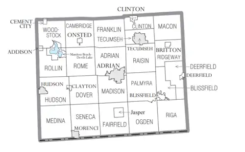
Villages
- Addison
- Blissfield
- Britton
- Cement City (partial)
- Clayton
- Clinton
- Deerfield
- Onsted
Charter townships
Civil townships
- Blissfield Township
- Cambridge Township
- Clinton Township
- Deerfield Township
- Dover Township
- Fairfield Township
- Franklin Township
- Hudson Township
- Macon Township
- Medina Township
- Ogden Township
- Palmyra Township
- Ridgeway Township
- Riga Township
- Rollin Township
- Rome Township
- Seneca Township
- Tecumseh Township
- Woodstock Township
Census-designated places
- Jasper (called Fairfield before 1874)
- Manitou Beach–Devils Lake
Other unincorporated communities
See also
Notes
- "Bibliography on Lenawee County". Clarke Historical Library, Central Michigan University. Retrieved January 20, 2013.
- "State & County QuickFacts". US Census Bureau. Retrieved September 15, 2021.
- "Find a County". National Association of Counties. Retrieved June 7, 2011.
- Wessel, Bob. "'Mound Builders' called Lenawee County home centuries before the familiar native tribes". The Daily Telegram. Adrian, Michigan. Retrieved April 11, 2022.
- Clark, Daniel J. (2018). "The Era of 'The Treaty of Detroit,' 1949–1950". Disruption in Detroit. University of Illinois Press. pp. 35–53. doi:10.5622/illinois/9780252042010.003.0003. ISBN 9780252042010.
- "Chronology of Adrian". Adrian Architecture. Retrieved April 11, 2022.
- Boursaw, Jane Louise (January 28, 2021). "Eric Hemenway Talks Indian Removal Act, Treaties & Odawa Leadership". Old Mission Gazette. Retrieved April 11, 2022.
- MSU American Indian and Indigenous Studies. "Land Acknowledgement". Reciprocal Research Guide. Michigan State University. Retrieved April 11, 2022.
- "Signers - Schoolcraft, Henry R." portal.treatysigners.org. Retrieved April 11, 2022.
- Michigan History, Arts and Libraries on sources of County names. Archived July 28, 2009, at the Wayback Machine
- "2010 Census Gazetteer Files". US Census Bureau. August 22, 2012. Retrieved September 26, 2014.
- "US Decennial Census". US Census Bureau. Retrieved September 26, 2014.
- "Historical Census Browser". University of Virginia Library. Retrieved September 26, 2014.
- "Population of Counties by Decennial Census: 1900 to 1990". US Census Bureau. Retrieved September 26, 2014.
- "Census 2000 PHC-T-4. Ranking Tables for Counties: 1990 and 2000" (PDF). US Census Bureau. Retrieved September 26, 2014.
- Leip, David. "Dave Leip's Atlas of U.S. Presidential Elections". uselectionatlas.org.
- "2022 government directory". www.lenawee.mi.us. April 2021.
{{cite web}}: CS1 maint: url-status (link) - "Lenawee county staff directory".
Further reading
- Bonner, Richard Illenden (1909). Memoirs of Lenawee County, Michigan: From the Earliest Historical Times Down to the Present, Including a Genealogical and Biographical Record of Representative Families in Lenawee County. Vol. 1. Madison, Wisconsin: Western Historical Association.
- Bonner, Richard Illenden (1909). Memoirs of Lenawee County, Michigan: From the Earliest Historical Times Down to the Present, Including a Genealogical and Biographical Record of Representative Families in Lenawee County. Vol. 2. Madison, Wisconsin: Western Historical Association.
- Bowen, Harriet Cole Clark (1973). Gravestone Records of Lenawee County. Salt Lake City: Genealogical Society of Utah.
- Burd, Jennifer & Strayer, Lad (2009). Daily Bread: A Portrait of Homeless Men and Women of Lenawee County, Michigan. Huron, Ohio: Bottom Dog Press.
- Burkett, Brenda L. (2017). Lenawee County. Images of America. Charleston, South Carolina: Arcadia. ISBN 9781467124034.
- Chapman Brothers (1888). Portrait and Biographical Album of Lenawee County, Mich.: Containing Full Page Portraits and Biographical Sketches of Prominent and Representative Citizens of the County... Chicago: Chapman Brothers.
- Deerfield Cooperative Association (n.d.). Lenawee County, Michigan Street and Road Atlas and History. Deerfield, Michigan: Deerfield Cooperative Association.
- Hogaboam, James J. (1876). The Bean Creek Valley: Incidents of Its Early Settlement: Collected from the Memories of Its Earliest Settlers, Now Living, and Verified by Reference to Official Documents. Hudson, Michigan: J. M. Scarritt.
- Kenyon Company (1921). Atlas and Plat Book of Lenawee County...Also, History and Atlas of the World War. Adrian, Michigan: Adrian Daily Telegram.
- Lenawee County Historical Society (1978). Combined Atlases of Lenawee County, Michigan: 1874, 1893, 1916. Evansville, Indiana: Unigraphic.
- Lennard, Ray (2016). Lenawee County and the Civil War. Charleston, South Carolina: The History Press.
- Lindquist, Charles N.; Eaton, Frederick G. & Ward-Eaton, Mary (1990). Lenawee County: A Harvest of Pride and Promise: An Illustrated History. Chatsworth, California: Windsor Publications.
- Lindquist, Charles N. (1999). The Antislavery-Underground Railroad Movement in Lenawee County, Michigan, 1830-1860. Adrian , Michigan: Lenawee County Historical Society.
- Long, Gertrude Miller (1980). Early Vacations at the Lakes of Lenawee County. Adrian, Michigan: Lenawee County Historical Society.
- Millard, Alfred L. (1876). Early History of Lenawee County and of the City of Adrian: From the First Settlement of the County: Historical Oration Delivered at Adrian, July 4, 1876. Adrian, Michigan: Times and Expositor Steam Press.
- Smith, Clarence L. (1874). Combination Atlas Map of Lenawee County, Michigan: Compiled, Drawn, and Published from Personal Experiences and Surveys. Chicago: Everts & Stewart.
- von Fange, Erich A. (1997). The Indians of Lenawee County. Tecumseh, Michigan: Erich A. von Fange.
External links
- Lenawee County Conference & Visitors Bureau
- Lenawee County Drain Commissioner
- Lenawee County Government Site
- Lenawee County Road Commission
- Complete text of History of Lenawee County published in 1909 by the Western Historical Society
- "Bibliography on Lenawee County". Clarke Historical Library, Central Michigan University.
- Lenawee County Directory Site
Places adjacent to Lenawee County, Michigan | ||||||||||||||||
|---|---|---|---|---|---|---|---|---|---|---|---|---|---|---|---|---|
| ||||||||||||||||
Municipalities and communities of Lenawee County, Michigan, United States | ||
|---|---|---|
| Cities | Map of Michigan highlighting Lenawee County.svg | |
| Villages | ||
| Charter townships | ||
| Civil townships | ||
| CDPs | ||
| Other unincorporated communities | ||
| Footnotes | ‡This populated place also has portions in an adjacent county or counties | |
| ||
| Topics |  | |
|---|---|---|
| Detroit | ||
| Municipalities over 80,000 | ||
| Municipalities 40,000 to 80,000 | ||
| Cultural enclaves | ||
| Satellite cities | ||
| Counties in MSA | ||
| Counties in CSA | ||